File:Central Italian dialects.png

Size of this preview: 656 × 599 pixels. Other resolutions: 263 × 240 pixels | 525 × 480 pixels | 841 × 768 pixels | 1,099 × 1,004 pixels.
Original file (1,099 × 1,004 pixels, file size: 102 KB, MIME type: image/png)
Captions
Captions
Add a one-line explanation of what this file represents
Summary edit
| Description |
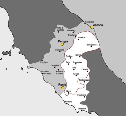
English: Map showing the areas where Central Italian dialects are spoken. Made by cross-referencing the map found on page 229 of the Oxford guide to the Romance languages with Pellegrini's Carta dei dialetti d'Italia. |
| Date | |
| Source | Own work |
| Author | Nicodene |
Licensing edit
I, the copyright holder of this work, hereby publish it under the following license:
This file is licensed under the Creative Commons Attribution-Share Alike 4.0 International license.
- You are free:
- to share – to copy, distribute and transmit the work
- to remix – to adapt the work
- Under the following conditions:
- attribution – You must give appropriate credit, provide a link to the license, and indicate if changes were made. You may do so in any reasonable manner, but not in any way that suggests the licensor endorses you or your use.
- share alike – If you remix, transform, or build upon the material, you must distribute your contributions under the same or compatible license as the original.
File history
Click on a date/time to view the file as it appeared at that time.
| Date/Time | Thumbnail | Dimensions | User | Comment | |
|---|---|---|---|---|---|
| current | 00:05, 21 January 2022 | | 1,099 × 1,004 (102 KB) | Nicodene (talk | contribs) | That red line was not supposed to extend to the Tyrrhenian Sea. |
| 23:52, 20 January 2022 |  | 1,099 × 1,004 (102 KB) | Nicodene (talk | contribs) | more toponyms | |
| 23:27, 20 January 2022 |  | 1,099 × 1,004 (93 KB) | Nicodene (talk | contribs) | Adding Fabriano | |
| 23:17, 20 January 2022 |  | 1,099 × 1,004 (91 KB) | Nicodene (talk | contribs) | Decided to greatly simplify the map by removing most isogloss lines. Added names of various locations as well for reference. | |
| 21:47, 20 January 2022 |  | 1,099 × 1,004 (53 KB) | Nicodene (talk | contribs) | Extended map southwards and incorporated details from Pellegrini's map more systematically. | |
| 10:14, 18 January 2022 |  | 1,102 × 839 (45 KB) | Nicodene (talk | contribs) | further nitpicking | |
| 10:05, 18 January 2022 |  | 1,102 × 839 (44 KB) | Nicodene (talk | contribs) | Adjustments to the border in northern Marche, per Pellegrini's Carta dei dialetti d'Italia. | |
| 09:21, 18 January 2022 |  | 1,102 × 839 (44 KB) | Nicodene (talk | contribs) | Adjustments to the northern border per the description on p. 228. | |
| 05:18, 18 January 2022 |  | 1,102 × 839 (44 KB) | Nicodene (talk | contribs) | Fixed a slight discolouration. | |
| 04:41, 18 January 2022 |  | 1,102 × 839 (43 KB) | Nicodene (talk | contribs) | Adding a marker for Perugia's location (useful for reference). |
You cannot overwrite this file.
File usage on Commons
The following 2 pages use this file:
File usage on other wikis
The following other wikis use this file:
- Usage on en.wikipedia.org
- Usage on www.wikidata.org