File:Central Turkey M7.8 finite fault surface projection.png
Size of this preview: 630 × 599 pixels. Other resolutions: 252 × 240 pixels | 505 × 480 pixels | 808 × 768 pixels | 1,077 × 1,024 pixels | 2,077 × 1,975 pixels.
Original file (2,077 × 1,975 pixels, file size: 1.74 MB, MIME type: image/png)
Captions
Captions
Add a one-line explanation of what this file represents
Summary
edit
| Description |
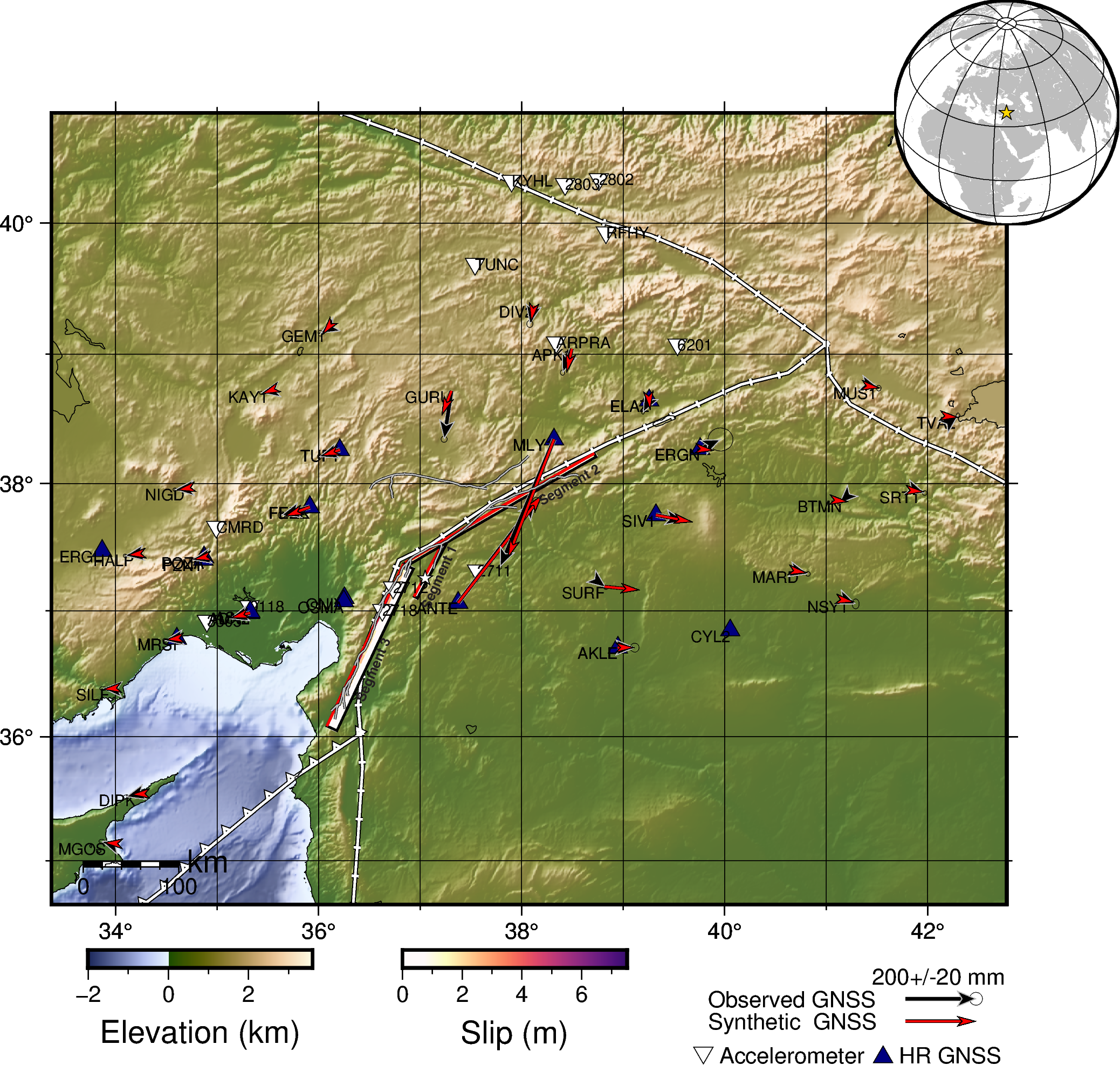
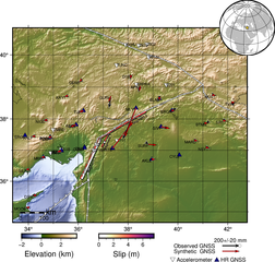
English: Mw 7.8 2023 Turkey-Syria earthquake USGS source model surface projection |
| Date | |
| Source | [1] |
| Author | United States Geological Survey |
Licensing
edit
This image is in the public domain in the United States because it only contains materials that originally came from the United States Geological Survey, an agency of the United States Department of the Interior. For more information, see the official USGS copyright policy.
|
File history
Click on a date/time to view the file as it appeared at that time.
| Date/Time | Thumbnail | Dimensions | User | Comment | |
|---|---|---|---|---|---|
| current | 01:12, 19 February 2023 | | 2,077 × 1,975 (1.74 MB) | Dora the Axe-plorer (talk | contribs) | updated |
| 04:33, 16 February 2023 |  | 2,077 × 1,981 (1.73 MB) | Dora the Axe-plorer (talk | contribs) | updated USGS basemap data | |
| 04:23, 14 February 2023 |  | 2,130 × 2,439 (5.68 MB) | Dora the Axe-plorer (talk | contribs) | updated USGS data | |
| 08:28, 13 February 2023 |  | 2,076 × 2,454 (5.93 MB) | Dora the Axe-plorer (talk | contribs) | Uploaded a work by United States Geological Survey from [https://earthquake.usgs.gov/earthquakes/eventpage/us6000jllz/finite-fault] with UploadWizard |
You cannot overwrite this file.
File usage on Commons
There are no pages that use this file.
File usage on other wikis
The following other wikis use this file:
- Usage on en.wikipedia.org
- Usage on es.wikipedia.org
- Usage on ku.wikipedia.org
- Usage on ms.wikipedia.org
- Usage on tum.wikipedia.org
- Usage on uz.wikipedia.org