File:Cfblvdmap.png

Size of this preview: 800 × 423 pixels. Other resolutions: 320 × 169 pixels | 640 × 338 pixels | 1,145 × 605 pixels.
Original file (1,145 × 605 pixels, file size: 104 KB, MIME type: image/png)
Captions
Captions
Add a one-line explanation of what this file represents
Summary
edit
| Description |
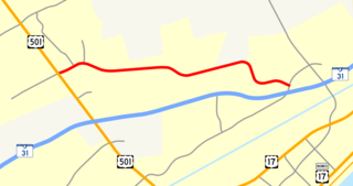
English: A map outlining w:Carolina Forest Boulevard in the community of w:Carolina Forest, South Carolina. |
| Date | |
| Source | I created this work entirely by myself, except for the United States and South Carolina highway shields within the image (also released into the public domain). |
| Author | Isipeoria (talk) |
Licensing
edit
| I, the copyright holder of this work, release this work into the public domain. This applies worldwide. In some countries this may not be legally possible; if so: I grant anyone the right to use this work for any purpose, without any conditions, unless such conditions are required by law. |
File history
Click on a date/time to view the file as it appeared at that time.
| Date/Time | Thumbnail | Dimensions | User | Comment | |
|---|---|---|---|---|---|
| current | 01:03, 13 January 2009 | | 1,145 × 605 (104 KB) | Isipeoria (talk | contribs) | {{Information |Description=A map outlining Carolina Forest Boulevard in the community of Carolina Forest, South Carolina. |Source=I created this work entirely by myself, except for the United States and South Carolina highway shields within the im |
You cannot overwrite this file.
File usage on Commons
There are no pages that use this file.
File usage on other wikis
The following other wikis use this file:
- Usage on en.wikipedia.org