File:Chagatai Khanate late 13th century locator map.svg

Original file (SVG file, nominally 811 × 646 pixels, file size: 278 KB)
Captions
Captions
Summary
edit
| Description |
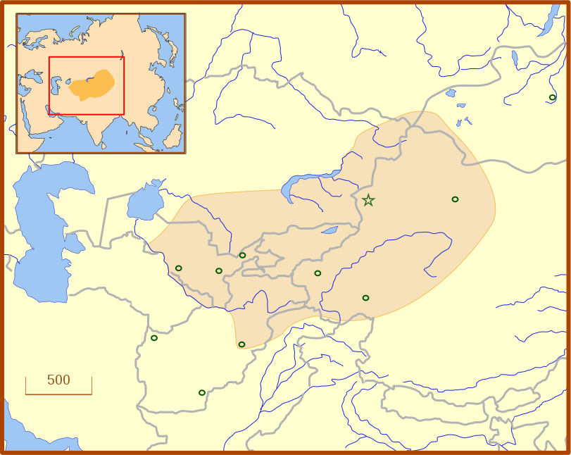
A locator map for the Chagatai Khanate in the late 13th century. The grey lines represent modern international borders. The blue represent rivers. This map uses a Lambert azimuthal equal-area projection. |
| Date | |
| Source | Own work |
| Author | MapMaster |
| Other versions | An English language version of the map. See also Image:Golden Horde 1389.svg |
References
edit
- Barnes, Ian; Robert Hudson (1998) The History Atlas of Asia, MacMillan, p. 87.
- Barraclough, Geoffrey (1993) The Times Atlas of World History, 4th Edition, Hammond World Atlas Corporation, ISBN 0723005346, p. 127.
- Facts on File (2002) Historical Maps on File: Ringbound, Facts on File, 2nd Edition, ISBN 081604600X, p. 2.27 "Mongol Invasions of Russian, 12th-13th Centuries".
- Map of the Mongol Empire archive copy at the Wayback Machine, Los Angeles County Museum of Art, accessed 8 July 2008.
These references do not completely agree on the borders of the Khanate. The Facts on File map, for example, shows the borders that stretch to the Caspian Sea, unlike the other three. The eastern border is also slightly different from map to map, which likely reflects the fact that the borders of the eastern half, the nomadic half, were never formally set.
Licensing
edit
- You are free:
- to share – to copy, distribute and transmit the work
- to remix – to adapt the work
- Under the following conditions:
- attribution – You must give appropriate credit, provide a link to the license, and indicate if changes were made. You may do so in any reasonable manner, but not in any way that suggests the licensor endorses you or your use.
File history
Click on a date/time to view the file as it appeared at that time.
| Date/Time | Thumbnail | Dimensions | User | Comment | |
|---|---|---|---|---|---|
| current | 03:07, 14 July 2008 | | 811 × 646 (278 KB) | MapMaster (talk | contribs) | Adde capital of Almalik |
| 04:19, 13 July 2008 |  | 811 × 646 (277 KB) | MapMaster (talk | contribs) | {{Information |Description=A locator map for the w:en:Chagatai Khanate in the late 13th century. |Source=self-made |Date=12 July 2008 |Author= MapMaster |Permission= |other_versions= }} |
You cannot overwrite this file.
File usage on Commons
There are no pages that use this file.
File usage on other wikis
The following other wikis use this file:
- Usage on an.wikipedia.org
- Usage on azb.wikipedia.org
- Usage on ba.wikipedia.org
- Usage on ca.wikipedia.org
- Usage on eo.wikipedia.org
- Usage on es.wikipedia.org
- Usage on fr.wikipedia.org
- Usage on hy.wikipedia.org
- Usage on ja.wikipedia.org
- Usage on ka.wikipedia.org
- Usage on kk.wikipedia.org
- Usage on ko.wikipedia.org
- Usage on nn.wikipedia.org
- Usage on ru.wikipedia.org
- Usage on tr.wikipedia.org
- Usage on tt.wikipedia.org
- Usage on uk.wikipedia.org
- Usage on uz.wikipedia.org
- Usage on zh.wikipedia.org