File:Chamonix, France 1924 (12350245095).jpg
Original file (5,000 × 5,000 pixels, file size: 5.52 MB, MIME type: image/jpeg)
Captions
Captions
Summary
edit.jpg&action=edit§ion=1)
| Description |
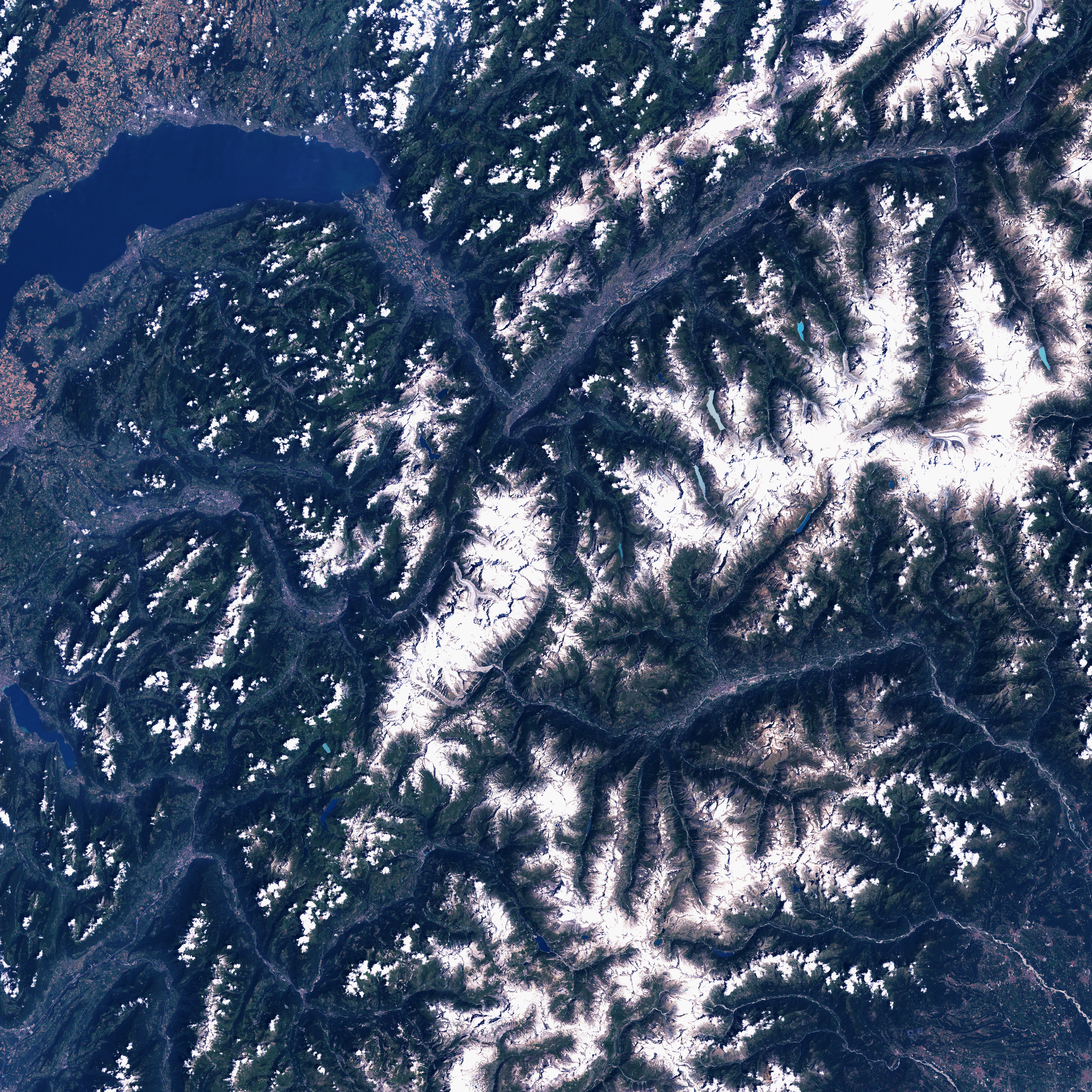
Mont Blanc, Chamonix, France Mount Blanc is the highest mountain in Western Europe. The eastern boundary of Europe is debated as there is no clear division between Europe and Asia as landmasses. Some definitions of the eastern boundary place the Caucasus Mountains of Russia in Asia, in which case Mt. Blanc is Europe’s tallest mountain and hence one of the Seven Summits (the tallest peaks on each of the seven continents). Its 4,807-meter-high (15,707-foot) peak lies in the ridgeline of the Pennine Alps and the peak defines the border between France and Italy. Its name means “White Mountain” in French, though in earlier centuries, it was also known as Mont Maudit, or the “Accursed Mountain.” Sixteenth Century legend has it that a temple and statue of the Celtic sky god was once located on one of the high passes near the mountain, and Christian myths tell of St. Bernard’s eventual domination of this “pagan devil,” from which the older name comes. The names of the nearby Great St. Bernard Pass (between Italy and Switzerland) and Col de Petit St. Bernard come from this historical figure as well. In addition to these two passes, there is a tunnel under the mountain offering a less challenging drive through the Alps. This image was acquired by Landsat 7’s Enhanced Thematic Mapper plus (ETM+) sensor on July 30, 2001. This is a true-color image made using red, green, and blue wavelengths (TM bands 3, 2, and 1). Landsat data from USGS EROS Data Center Satellite Systems Branch More info: earthobservatory.nasa.gov/IOTD/view.php?id=3620 Credit: NASA Earth Observatory |
| Date | |
| Source | Chamonix, France 1924 |
| Author | NASA Goddard Space Flight Center from Greenbelt, MD, USA |
Licensing
edit.jpg&action=edit§ion=2)
- You are free:
- to share – to copy, distribute and transmit the work
- to remix – to adapt the work
- Under the following conditions:
- attribution – You must give appropriate credit, provide a link to the license, and indicate if changes were made. You may do so in any reasonable manner, but not in any way that suggests the licensor endorses you or your use.
| This image was originally posted to Flickr by NASA Goddard Photo and Video at https://flickr.com/photos/24662369@N07/12350245095. It was reviewed on 17 September 2016 by FlickreviewR and was confirmed to be licensed under the terms of the cc-by-2.0. |
| This file is in the public domain in the United States because it was solely created by NASA. NASA copyright policy states that "NASA material is not protected by copyright unless noted". (See Template:PD-USGov, NASA copyright policy page or JPL Image Use Policy.) | ||
 |
Warnings:
|
File history
Click on a date/time to view the file as it appeared at that time.
| Date/Time | Thumbnail | Dimensions | User | Comment | |
|---|---|---|---|---|---|
| current | 20:46, 17 September 2016 | | 5,000 × 5,000 (5.52 MB) | Vanished Account Byeznhpyxeuztibuo (talk | contribs) | Transferred from Flickr via Flickr2Commons |
You cannot overwrite this file.
File usage on Commons
There are no pages that use this file.
.jpg&oldid=894524544)