File:Chantry Lane Ford - geograph.org.uk - 805216.jpg
No higher resolution available.
Chantry_Lane_Ford_-_geograph.org.uk_-_805216.jpg (640 × 480 pixels, file size: 209 KB, MIME type: image/jpeg)
Captions
Captions
Add a one-line explanation of what this file represents
Summary edit
| Description |
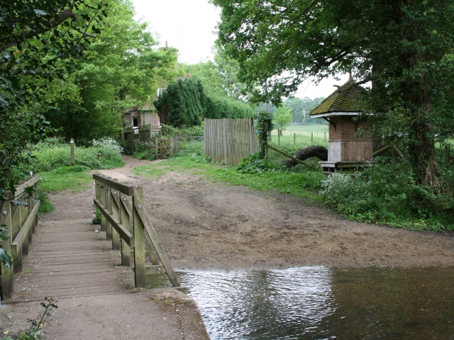
English: Chantry Lane Ford. The ford lies at the bottom of Chantry Lane (D225): Dark Lane (bridleway Shere 151) to Shere Heath continues ahead to the left of Dark Lane Cottage, to the right of the cottage, a gate gives access to footpath Shere 148 across Albury Park to Park Road, and a footpath (also Shere 148) leads left from the opposite side of the footbridge into the village of Shere (and affords this view of 655869). On the other side and to the right of the ford is what appears to be a rustic shelter... 805181. |
| Date | |
| Source | From geograph.org.uk |
| Author | Hugh Craddock |
| Attribution (required by the license) | Hugh Craddock / Chantry Lane Ford / |
| Camera location | | View this and other nearby images on: OpenStreetMap |
|---|
_heading:157.00&language=en)
| Object location | | View this and other nearby images on: OpenStreetMap |
|---|
_heading:157.00&language=en)
Licensing edit

|
This image was taken from the Geograph project collection. See this photograph's page on the Geograph website for the photographer's contact details. The copyright on this image is owned by Hugh Craddock and is licensed for reuse under the Creative Commons Attribution-ShareAlike 2.0 license.
|
This file is licensed under the Creative Commons Attribution-Share Alike 2.0 Generic license.
Attribution: Hugh Craddock
- You are free:
- to share – to copy, distribute and transmit the work
- to remix – to adapt the work
- Under the following conditions:
- attribution – You must give appropriate credit, provide a link to the license, and indicate if changes were made. You may do so in any reasonable manner, but not in any way that suggests the licensor endorses you or your use.
- share alike – If you remix, transform, or build upon the material, you must distribute your contributions under the same or compatible license as the original.
File history
Click on a date/time to view the file as it appeared at that time.
| Date/Time | Thumbnail | Dimensions | User | Comment | |
|---|---|---|---|---|---|
| current | 07:52, 20 February 2011 | | 640 × 480 (209 KB) | GeographBot (talk | contribs) | == {{int:filedesc}} == {{Information |description={{en|1=Chantry Lane Ford The ford lies at the bottom of Chantry Lane (D225): Dark Lane (bridleway Shere 151) to Shere Heath continues ahead to the left of Dark Lane Cottage, to the right of the cottage, a |
You cannot overwrite this file.
File usage on Commons
There are no pages that use this file.