File:Chaos Crags and Chaos Jumbles in June 2020.jpg

Size of this preview: 800 × 533 pixels. Other resolutions: 320 × 213 pixels | 640 × 427 pixels | 1,024 × 683 pixels | 1,280 × 853 pixels | 2,560 × 1,707 pixels | 6,720 × 4,480 pixels.
Original file (6,720 × 4,480 pixels, file size: 31.46 MB, MIME type: image/jpeg)
Captions
Captions
Add a one-line explanation of what this file represents
Summary
edit
| Description |
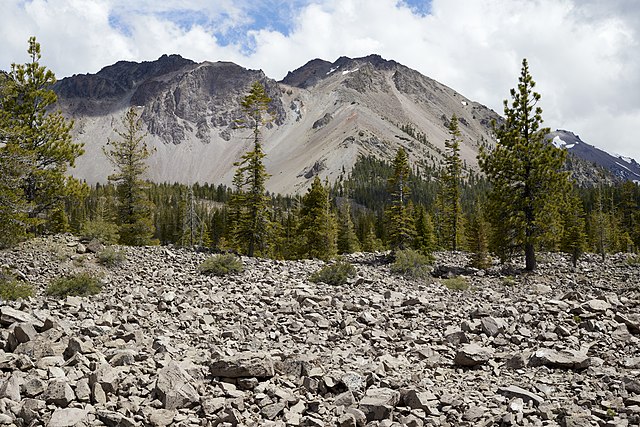
English: Chaos Crags lavadomes and Chaos Jumbles rock debris as seen from California State Route 89 on June 12, 2020. Chaos Jumbles are the remains of a rock avalanche that devastated the area when one of the Chaos Crags domes erupted about 350 years ago. Riding on a cushion of compressed air, the rock debris traveled at about 100 miles per hour on Chaos Crags’ northwest slope. |
| Date | |
| Source | Own work |
| Author | Frank Schulenburg |
| Camera location | | View this and other nearby images on: OpenStreetMap |
|---|
Licensing
edit
I, the copyright holder of this work, hereby publish it under the following license:
This file is licensed under the Creative Commons Attribution-Share Alike 4.0 International license.
- You are free:
- to share – to copy, distribute and transmit the work
- to remix – to adapt the work
- Under the following conditions:
- attribution – You must give appropriate credit, provide a link to the license, and indicate if changes were made. You may do so in any reasonable manner, but not in any way that suggests the licensor endorses you or your use.
- share alike – If you remix, transform, or build upon the material, you must distribute your contributions under the same or compatible license as the original.
File history
Click on a date/time to view the file as it appeared at that time.
| Date/Time | Thumbnail | Dimensions | User | Comment | |
|---|---|---|---|---|---|
| current | 22:53, 13 June 2020 | | 6,720 × 4,480 (31.46 MB) | Frank Schulenburg (talk | contribs) | Uploaded own work with UploadWizard |
You cannot overwrite this file.
File usage on Commons
The following page uses this file:
File usage on other wikis
The following other wikis use this file:
- Usage on en.wikipedia.org
- Usage on it.wikipedia.org
- Usage on www.wikidata.org