File:Chapel on the Mass Grave of the Crimean War 1854-55.JPG
Chapel_on_the_Mass_Grave_of_the_Crimean_War_1854-55.JPG (399 × 600 pixels, file size: 118 KB, MIME type: image/jpeg)
Captions
Captions
Summary
editCamera location | 44° 45′ 09.21″ N, 33° 53′ 06.41″ E ![]() | View this and other nearby images on: OpenStreetMap | ![]() |
---|
DescriptionChapel on the Mass Grave of the Crimean War 1854-55.JPG |
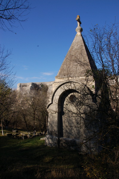
Українська: Назва за держреєстром пам'яток: "Братська могила російських воїнів (більше 2-х тисяч чоловік) каплиця"
|
||
Date | |||
Source | Own work | ||
Author | Oleksa Haiworonski |
Licensing
edit![w:en:Creative Commons](https://upload.wikimedia.org/wikipedia/commons/thumb/7/79/CC_some_rights_reserved.svg/90px-CC_some_rights_reserved.svg.png)
![attribution](https://upload.wikimedia.org/wikipedia/commons/thumb/1/11/Cc-by_new_white.svg/24px-Cc-by_new_white.svg.png)
![share alike](https://upload.wikimedia.org/wikipedia/commons/thumb/d/df/Cc-sa_white.svg/24px-Cc-sa_white.svg.png)
- You are free:
- to share – to copy, distribute and transmit the work
- to remix – to adapt the work
- Under the following conditions:
- attribution – You must give appropriate credit, provide a link to the license, and indicate if changes were made. You may do so in any reasonable manner, but not in any way that suggests the licensor endorses you or your use.
- share alike – If you remix, transform, or build upon the material, you must distribute your contributions under the same or compatible license as the original.
![]() |
This image was uploaded as part of Wiki Loves Monuments 2012.
Afrikaans ∙ Alemannisch ∙ azərbaycanca ∙ Bahasa Indonesia ∙ Bahasa Melayu ∙ Bikol Central ∙ bosanski ∙ brezhoneg ∙ català ∙ čeština ∙ Cymraeg ∙ dansk ∙ davvisámegiella ∙ Deutsch ∙ eesti ∙ English ∙ español ∙ Esperanto ∙ euskara ∙ français ∙ Frysk ∙ Gaeilge ∙ galego ∙ hrvatski ∙ Ido ∙ italiano ∙ latviešu ∙ Lëtzebuergesch ∙ Malagasy ∙ magyar ∙ Malti ∙ Nederlands ∙ norsk ∙ norsk nynorsk ∙ norsk bokmål ∙ polski ∙ português ∙ português do Brasil ∙ română ∙ shqip ∙ sicilianu ∙ slovenčina ∙ slovenščina ∙ suomi ∙ svenska ∙ Tagalog ∙ Türkçe ∙ Yorùbá ∙ Zazaki ∙ Ελληνικά ∙ беларуская ∙ беларуская (тарашкевіца) ∙ български ∙ кыргызча ∙ македонски ∙ русский ∙ српски / srpski ∙ українська ∙ ქართული ∙ հայերեն ∙ नेपाली ∙ हिन्दी ∙ বাংলা ∙ മലയാളം ∙ ไทย ∙ 한국어 ∙ +/− |
![]() |
File history
Click on a date/time to view the file as it appeared at that time.
Date/Time | Thumbnail | Dimensions | User | Comment | |
---|---|---|---|---|---|
current | 22:41, 8 September 2012 | 399 × 600 (118 KB) | Oleksa Haiworonski (talk | contribs) | User created page with UploadWizard |
You cannot overwrite this file.
File usage on Commons
The following page uses this file:
File usage on other wikis
The following other wikis use this file:
- Usage on ru.wikivoyage.org
- Usage on uk.wikipedia.org
- Вікіпедія:Вікі любить пам'ятки/Автономна Республіка Крим/Бахчисарайський район
- Вікіпедія:Wiki Loves Monuments/Автономна Республіка Крим/Бахчисарайський район
- Вікіпедія:Вікі любить пам'ятки/Автономна Республіка Крим/Бахчисарай
- Вікіпедія:Вікі любить пам'ятки/новий АТУ/Автономна Республіка Крим/Бахчисарайський район
- Usage on www.wikidata.org
Metadata
This file contains additional information such as Exif metadata which may have been added by the digital camera, scanner, or software program used to create or digitize it. If the file has been modified from its original state, some details such as the timestamp may not fully reflect those of the original file. The timestamp is only as accurate as the clock in the camera, and it may be completely wrong.
Camera manufacturer | NIKON CORPORATION |
---|---|
Camera model | NIKON D50 |
Exposure time | 1/250 sec (0.004) |
F-number | f/6.7 |
Date and time of data generation | 12:12, 18 November 2009 |
Lens focal length | 26 mm |
User comments |
|
Latitude | 44° 45′ 9.21″ N |
Longitude | 33° 53′ 6.41″ E |
Altitude | 293.363 meters above sea level |
Orientation | Normal |
Horizontal resolution | 300 dpi |
Vertical resolution | 300 dpi |
Software used | ACDSee Pro 5 |
File change date and time | 01:39, 9 September 2012 |
Y and C positioning | Centered |
Exposure Program | Aperture priority |
Exif version | 2.21 |
Date and time of digitizing | 12:12, 18 November 2009 |
Meaning of each component |
|
Image compression mode | 4 |
APEX exposure bias | 0 |
Maximum land aperture | 4 APEX (f/4) |
Metering mode | Pattern |
Light source | Unknown |
Flash | Flash did not fire |
DateTime subseconds | 421 |
DateTimeOriginal subseconds | 50 |
DateTimeDigitized subseconds | 50 |
Supported Flashpix version | 1 |
Color space | sRGB |
Sensing method | One-chip color area sensor |
File source | Digital still camera |
Scene type | A directly photographed image |
Custom image processing | Normal process |
Exposure mode | Auto exposure |
White balance | Auto white balance |
Digital zoom ratio | 1 |
Focal length in 35 mm film | 39 mm |
Scene capture type | Standard |
Scene control | None |
Contrast | Normal |
Saturation | Normal |
Sharpness | Normal |
Subject distance range | Unknown |
GPS tag version | 2.2.0.0 |
Image height | 3,008 px |
Image width | 2,000 px |