File:Charcoal kilns 01.jpg
Charcoal_kilns_01.jpg (800 × 600 pixels, file size: 92 KB, MIME type: image/jpeg)
Captions
Captions
| Public domainPublic domainfalsefalse |
This image is in the public domain in the United States because it only contains materials that originally came from the United States Geological Survey, an agency of the United States Department of the Interior. For more information, see the official USGS copyright policy.
Bahasa Indonesia ∙ català ∙ čeština ∙ Deutsch ∙ eesti ∙ English ∙ español ∙ français ∙ galego ∙ italiano ∙ Nederlands ∙ português ∙ polski ∙ sicilianu ∙ suomi ∙ Tiếng Việt ∙ Türkçe ∙ български ∙ македонски ∙ русский ∙ മലയാളം ∙ 한국어 ∙ 日本語 ∙ 中文 ∙ 中文(简体) ∙ 中文(繁體) ∙ العربية ∙ فارسی ∙ +/− |
Death Valley - California - [1]
Charcoal kiln edit
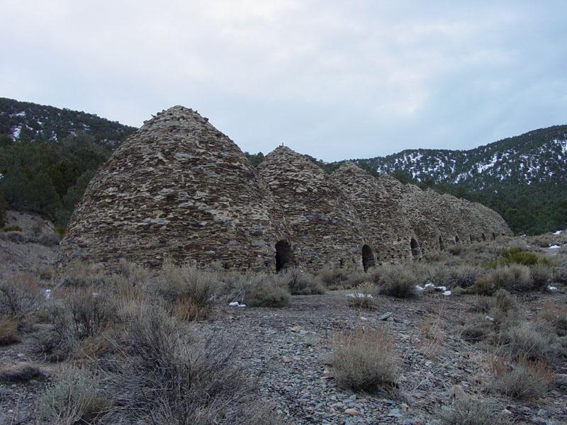
These charcoal kilns are located in upper Wildrose Canyon in the Panamint Mountians along the access road to the Thorndike and Mahogany Flat campgrounds in the Panamint Range. The kilns are about 8.5 miles east of the Wildrose Ranger Station.
Each beehive-shaped charcoal kiln is approximately 30 feet tall and 30 feet in diameter and made of local stone and mortar. The kilns were built in 1877 to produce charcoal from the surrounding piñon pine and juniper forest in the Panamint Range around Mahogany Flat to provide fuel to the Madoc Mine smelter, 25 miles to the west across the Panamint Valley.
Forno per la produzione di carbone di legna edit
Questi forni di carbone di legna sono situati nella parte superiore del canalone di Wildrose nel Panamint Mountians lungo la via di accesso al Thorndike ed ai campi di tende del Mahogany Flat, nella catena del Panamint. I forni sono a circa 14 chilometri ad est della stazione dei ranger di Wildrose
Ogni forno di carbone di legna, ha forma di alveare, è alto circa 9 metri e 9 metri di diametro ed è fatto in pietra locale e malta. I forni sono stati costruiti nel 1877 per produrre carbone di legna dalla foresta circostante di pino e ginepro della catena del Panamint intorno al Mahogany Flat (piano di mogano) per fornire il combustibile alla fonderia della miniera di Madoc, 40 chilometri ad ovest dalla valle del Panamint.
File history
Click on a date/time to view the file as it appeared at that time.
| Date/Time | Thumbnail | Dimensions | User | Comment | |
|---|---|---|---|---|---|
| current | 21:19, 18 July 2005 |  | 800 × 600 (92 KB) | Roger469 (talk | contribs) | {{PD-USGov-Interior-NPS}} http://3dparks.wr.usgs.gov/deathvalley2/html/charcoalkilns.htm These charcoal kilns are located in upper Wildrose Canyon in the Panamint Mountians along the access road to the Thorndike and Mahogany Flat campgrounds in the Pa |
You cannot overwrite this file.
File usage on Commons
The following page uses this file:
File usage on other wikis
The following other wikis use this file:
- Usage on it.wikipedia.org
Metadata
This file contains additional information such as Exif metadata which may have been added by the digital camera, scanner, or software program used to create or digitize it. If the file has been modified from its original state, some details such as the timestamp may not fully reflect those of the original file. The timestamp is only as accurate as the clock in the camera, and it may be completely wrong.
| _error | 0 |
|---|

