File:Charlotte districts map.png

Size of this preview: 683 × 600 pixels. Other resolutions: 273 × 240 pixels | 547 × 480 pixels | 875 × 768 pixels | 1,166 × 1,024 pixels | 2,333 × 2,048 pixels | 3,000 × 2,634 pixels.
Original file (3,000 × 2,634 pixels, file size: 748 KB, MIME type: image/png)
Captions
Captions
Add a one-line explanation of what this file represents
Summary
edit
| Description |
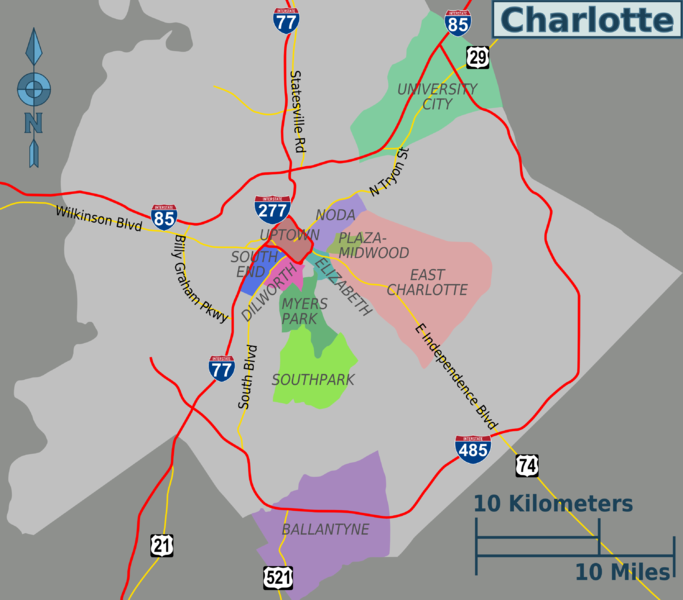
English: Charlotte districts map. English. |
| Date | |
| Source | Image:Charlotte districts map.svg |
| Author | Peter Fitzgerald, OpenStreetMap.org |
Licensing
edit
This file is licensed under the Creative Commons Attribution-Share Alike 2.0 Generic license.
- You are free:
- to share – to copy, distribute and transmit the work
- to remix – to adapt the work
- Under the following conditions:
- attribution – You must give appropriate credit, provide a link to the license, and indicate if changes were made. You may do so in any reasonable manner, but not in any way that suggests the licensor endorses you or your use.
- share alike – If you remix, transform, or build upon the material, you must distribute your contributions under the same or compatible license as the original.
Original upload log
edit
| This file was imported from Wikivoyage WTS. |
The original description page was here. All following user names refer to wts.wikivoyage-old.
- 2009-02-09 17:01 (WT-shared) Peterfitzgerald archive copy at the Wayback Machine 3000×2634 (766147 bytes) {{Imagecredit|credit=Peter Fitzgerald, OpenStreetMap.org|captureDate=9 February 2009|location=Charlotte|source=[[:Image:Charlotte districts (Import from wikitravel.org/shared)
File history
Click on a date/time to view the file as it appeared at that time.
| Date/Time | Thumbnail | Dimensions | User | Comment | |
|---|---|---|---|---|---|
| current | 23:10, 17 November 2012 | | 3,000 × 2,634 (748 KB) | MGA73bot2 (talk | contribs) | {{BotMoveToCommons|wts.oldwikivoyage|year={{subst:CURRENTYEAR}}|month={{subst:CURRENTMONTHNAME}}|day={{subst:CURRENTDAY}}}} == {{int:filedesc}} == {{Information |description=Charlotte districts map. English, Charlotte * Map of: Charlotte¤ |date=9 Febr... |
You cannot overwrite this file.
File usage on Commons
There are no pages that use this file.
File usage on other wikis
The following other wikis use this file:
- Usage on en.wikivoyage.org
- Usage on it.wikivoyage.org
- Usage on pl.wikivoyage.org