File:Charlotte uptown map.svg

Size of this PNG preview of this SVG file: 512 × 315 pixels. Other resolutions: 320 × 197 pixels | 640 × 394 pixels | 1,024 × 630 pixels | 1,280 × 788 pixels | 2,560 × 1,575 pixels.
Original file (SVG file, nominally 512 × 315 pixels, file size: 117 KB)
Captions
Captions
Add a one-line explanation of what this file represents
Summary edit
| Description |
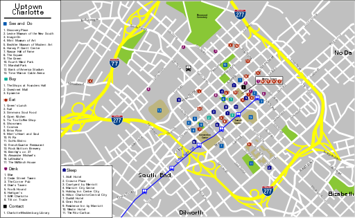
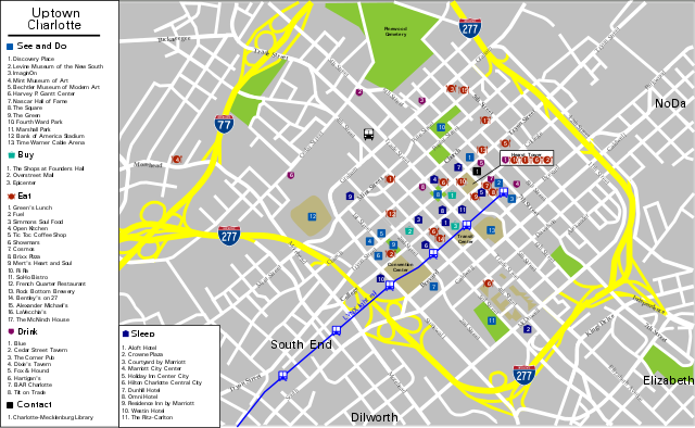
English: Uptown Charlotte Map, Charlotte. |
| Date | 11/3/07 |
| Source | |
| Author | PerryPlanet |
| SVG development |
Licensing edit
This file is licensed under the Creative Commons Attribution-Share Alike 4.0 International, 3.0 Unported, 2.5 Generic, 2.0 Generic and 1.0 Generic license.
- You are free:
- to share – to copy, distribute and transmit the work
- to remix – to adapt the work
- Under the following conditions:
- attribution – You must give appropriate credit, provide a link to the license, and indicate if changes were made. You may do so in any reasonable manner, but not in any way that suggests the licensor endorses you or your use.
- share alike – If you remix, transform, or build upon the material, you must distribute your contributions under the same or compatible license as the original.
Original upload log edit
| This file was imported from Wikivoyage WTS. |
The original description page was here. All following user names refer to wts.wikivoyage-old.
- 2010-04-05 20:14 (WT-shared) PerryPlanet[dead link] 744×1052 (551010 bytes) {{Imagecredit|credit=PerryPlanet|captureDate=11/3/07|location=Charlotte|source=|caption=Uptown Charlotte Map|description=}}{{Map|Charlotte}} (Import from wikitravel.org/shared)
- 2012-09-13 01:57 LtPowers[dead link] 1600×1086 (479689 bytes) Remove old logo
- 2012-10-21 06:41 PerryPlanet[dead link] 1600×1086 (456855 bytes) updated version
- 2012-10-21 16:29 PerryPlanet[dead link] 1600×1086 (457524 bytes) fixed typo
File history
Click on a date/time to view the file as it appeared at that time.
| Date/Time | Thumbnail | Dimensions | User | Comment | |
|---|---|---|---|---|---|
| current | 22:52, 27 April 2018 | | 512 × 315 (117 KB) | JoKalliauer (talk | contribs) | partly retraced |
| 18:44, 27 April 2018 |  | 512 × 315 (135 KB) | JoKalliauer (talk | contribs) | removed flow-text (but I think there are sill some librsvgproblems) | |
| 06:37, 22 November 2012 |  | 1,600 × 1,086 (447 KB) | OgreBot (talk | contribs) | (BOT): Reverting to most recent version before archival | |
| 06:37, 22 November 2012 |  | 1,600 × 1,086 (446 KB) | OgreBot (talk | contribs) | (BOT): Uploading old version of file from wts.wikivoyage; originally uploaded on 2012-10-21 06:41:38 by PerryPlanet | |
| 06:37, 22 November 2012 |  | 1,600 × 1,086 (468 KB) | OgreBot (talk | contribs) | (BOT): Uploading old version of file from wts.wikivoyage; originally uploaded on 2012-09-13 01:57:11 by LtPowers | |
| 06:37, 22 November 2012 |  | 744 × 1,052 (538 KB) | OgreBot (talk | contribs) | (BOT): Uploading old version of file from wts.wikivoyage; originally uploaded on 2010-04-05 20:14:15 by (WT-shared) PerryPlanet | |
| 23:11, 17 November 2012 |  | 1,600 × 1,086 (447 KB) | MGA73bot2 (talk | contribs) | {{BotMoveToCommons|wts.oldwikivoyage|year={{subst:CURRENTYEAR}}|month={{subst:CURRENTMONTHNAME}}|day={{subst:CURRENTDAY}}}} == {{int:filedesc}} == {{Information |description=Uptown Charlotte Map. , Charlotte * Map of: Charlotte¤ |date=11/3/07 |source=... |
You cannot overwrite this file.
File usage on Commons
The following 5 pages use this file: