File:Cheonan incident map.svg

Size of this PNG preview of this SVG file: 400 × 550 pixels. Other resolutions: 174 × 240 pixels | 349 × 480 pixels | 558 × 768 pixels | 745 × 1,024 pixels | 1,489 × 2,048 pixels.
Original file (SVG file, nominally 400 × 550 pixels, file size: 1.69 MB)
Captions
Captions
Add a one-line explanation of what this file represents
Summary
edit| Description |
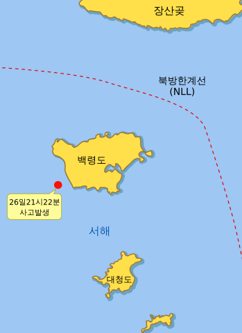
한국어: 천안함 침몰 사고 지도 |
| Date | |
| Source | ko:commons:File:Baekryong_location_2.svg를 바탕으로 제작, 사고발생위치는 국방부 발표 좌표 37.55n 124.37e으로 맞춤. |
| Author | 사용자:Perplexing (원본: ko:Commons:User:Amble) |
| Other versions |

Licensing
edit
This file is licensed under the Creative Commons Attribution-Share Alike 3.0 Unported license.
- You are free:
- to share – to copy, distribute and transmit the work
- to remix – to adapt the work
- Under the following conditions:
- attribution – You must give appropriate credit, provide a link to the license, and indicate if changes were made. You may do so in any reasonable manner, but not in any way that suggests the licensor endorses you or your use.
- share alike – If you remix, transform, or build upon the material, you must distribute your contributions under the same or compatible license as the original.
File history
Click on a date/time to view the file as it appeared at that time.
| Date/Time | Thumbnail | Dimensions | User | Comment | |
|---|---|---|---|---|---|
| current | 12:00, 3 May 2010 | | 400 × 550 (1.69 MB) | Perplexing (talk | contribs) | {{파일 정보 |설명= 천안함 침몰 사고 지도 |출처= commons:File:Baekryong_location_2.svg를 바탕으로 제작, 사고발생위치는 국방부 발표 좌표 37.55n 124.37e으로 맞춤. |날짜= 2010-05-03 |만든이= [[사용자:Perpl |
| 21:19, 2 May 2010 |  | 400 × 550 (54 KB) | Perplexing (talk | contribs) | {{파일 정보 |설명= 천안함 침몰 사고 지도 |출처= commons:File:Baekryong_location_2.svg를 바탕으로 제작, 사고발생위치는 국방부 발표 좌표 37.55n 124.37e으로 맞춤. |날짜= 2010-05-03 |만든이= 사용자:Per |
You cannot overwrite this file.
File usage on Commons
There are no pages that use this file.
File usage on other wikis
The following other wikis use this file:
- Usage on ko.wikipedia.org