File:Cherkasy regions.svg

Size of this PNG preview of this SVG file: 728 × 599 pixels. Other resolutions: 292 × 240 pixels | 583 × 480 pixels | 933 × 768 pixels | 1,244 × 1,024 pixels | 2,487 × 2,048 pixels | 991 × 816 pixels.
Original file (SVG file, nominally 991 × 816 pixels, file size: 384 KB)
Captions
Captions
Add a one-line explanation of what this file represents
Summary
edit
| Description |
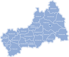
Українська: Cherkasy_regions.svg: English: Map of the regions of Cherkasy Oblast (province), central Ukraine.
Українська: Опис — Карта-схема Черкаської області |
| Date | |
| Source | Own work |
| Author | Катерина Ткачова (uk:Користувач:Kaha) |
| Permission (Reusing this file) |
This file is licensed under the Creative Commons Attribution-Share Alike 3.0 Unported license.
|

|
This SVG file contains embedded text that can be translated into your language, using any capable SVG editor, text editor or the SVG Translate tool. For more information see: About translating SVG files. |
Original upload log
edit
The original description page was here. All following user names refer to uk.wikipedia.
| Upload date | User | Bytes | Dimensions | Comment |
|---|---|---|---|---|
| 2009-01-20 09:48:36 | VictorAnyakin | 466645 | 991×816 | {{Зображення |Назва=Cherkasy_regions.svg |Опис=Карта-схема Черкаської області |Автор=Катерина Ткачова ([[Користувач:Kaha]]) |Джерело= |Час створення= |Ліце� |
File history
Click on a date/time to view the file as it appeared at that time.
| Date/Time | Thumbnail | Dimensions | User | Comment | |
|---|---|---|---|---|---|
| current | 18:45, 28 May 2012 | | 991 × 816 (384 KB) | Ahonc (talk | contribs) | fix Уманський |
| 18:18, 28 May 2012 |  | 991 × 816 (387 KB) | Texnik (talk | contribs) | now you can edit name | |
| 15:49, 28 May 2012 |  | 991 × 816 (471 KB) | Texnik (talk | contribs) | correct name | |
| 00:11, 13 January 2012 |  | 991 × 816 (456 KB) | File Upload Bot (Magnus Manske) (talk | contribs) | {{BotMoveToCommons|uk.wikipedia|year={{subst:CURRENTYEAR}}|month={{subst:CURRENTMONTHNAME}}|day={{subst:CURRENTDAY}}}} {BotMoveToCommons|uk.wikipedia|year={{subst:CURRENTYEAR}}|month={{subst:CURRENTMONTHNAME}}|day={{subst:CURRENTDAY}}}} == Опис фа� |
You cannot overwrite this file.
File usage on Commons
The following 20 pages use this file:
- Commons:Graphic Lab/Map workshop/Archive/2012
- File:Cherkasy regions Cherkasy.svg
- File:Cherkasy regions Chornobay.svg
- Category:Architecture in Cherkasy Oblast
- Category:Births in Cherkasy Oblast
- Category:Bodies of water in Cherkasy Oblast
- Category:Cherkasy Oblast
- Category:Geography of Cherkasy Oblast
- Category:Lakes of Cherkasy Oblast
- Category:Maps of Cherkasy Oblast
- Category:Monasteries in Cherkasy Oblast
- Category:People of Cherkasy Oblast
- Category:Populated places in Cherkasy Oblast
- Category:Raions of Cherkasy Oblast
- Category:Roads in Cherkasy Oblast
- Category:Rural settlements in Cherkasy Oblast
- Category:Sports in Cherkasy Oblast
- Category:Stadiums in Cherkasy Oblast
- Category:Views of Cherkasy Oblast
- Category:Villages in Cherkasy Oblast
File usage on other wikis
The following other wikis use this file:
- Usage on ba.wikipedia.org
- Usage on bg.wikipedia.org
- Usage on da.wikipedia.org
- Usage on en.wikipedia.org
- Usage on es.wikipedia.org
- Usage on hy.wikipedia.org
- Usage on pl.wikipedia.org
- Usage on pl.wikivoyage.org
- Usage on ru.wikipedia.org
- Usage on uk.wikipedia.org
- Обговорення:Населення Черкаської області
- Обговорення:Білашки (Звенигородський район)
- Обговорення:Веселий Кут (Тальнівська міська громада)
- Обговорення:Вишнопіль (Звенигородський район)
- Обговорення:Глибочок (Звенигородський район)
- Обговорення:Гордашівка
- Обговорення:Гуляйка
- Обговорення:Заліське
- Обговорення:Корнилівка
- Шаблон:Cherkasy Oblast-week-new
- Шаблон:Cherkasy Oblast-week-improve
- Обговорення:Лисенко Іван Йосипович
- Обговорення:Голубець Іван Карпович
- Обговорення:Степаненко Іван Никифорович
- Обговорення:Хоругва Канева
- Обговорення:Закревський бір
- Обговорення:Великобурімський парк
- Обговорення:Герб Канева
- Обговорення:Петропавлівський храм (Тальне)
- Обговорення:Автошлях E95
- Обговорення:Драченко Іван Григорович
- Обговорення:Андрющенко Яків Трохимович
- Обговорення:Черкаська обласна державна адміністрація
- Обговорення:Керівники Черкаської області
- Обговорення:Черняховський Іван Данилович
- Обговорення:Історія Тального
- Обговорення:Бердичевський Леонід Опанасович
View more global usage of this file.