File:Chiang Mai road system.svg

Size of this PNG preview of this SVG file: 316 × 599 pixels. Other resolutions: 126 × 240 pixels | 253 × 480 pixels | 405 × 768 pixels | 540 × 1,024 pixels | 1,079 × 2,048 pixels | 563 × 1,068 pixels.
Original file (SVG file, nominally 563 × 1,068 pixels, file size: 374 KB)
Captions
Captions
Add a one-line explanation of what this file represents
Summary edit
| Description |
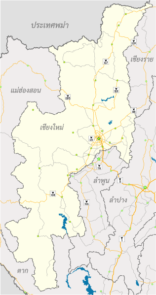
English: Chiang Mai road network with neighbors, location of districts and highway signs
ไทย: โครงข่ายถนนในจังหวัดเชียงใหม่และจังหวัดใกล้เคียง (รูปดาวแสดงที่ตั้งอำเภอเมืองและอำเภอต่าง ๆ) |
| Date | |
| Source | Own work |
| Author | Ponpan |
| Other versions |
|


This W3C-unspecified vector image was created with Inkscape .
Licensing edit
I, the copyright holder of this work, hereby publish it under the following license:
This file is licensed under the Creative Commons Attribution-Share Alike 4.0 International license.
- You are free:
- to share – to copy, distribute and transmit the work
- to remix – to adapt the work
- Under the following conditions:
- attribution – You must give appropriate credit, provide a link to the license, and indicate if changes were made. You may do so in any reasonable manner, but not in any way that suggests the licensor endorses you or your use.
- share alike – If you remix, transform, or build upon the material, you must distribute your contributions under the same or compatible license as the original.
File history
Click on a date/time to view the file as it appeared at that time.
| Date/Time | Thumbnail | Dimensions | User | Comment | |
|---|---|---|---|---|---|
| current | 10:06, 31 January 2016 | | 563 × 1,068 (374 KB) | Ponpan (talk | contribs) | +highway signs |
| 09:21, 31 January 2016 |  | 563 × 1,068 (223 KB) | Ponpan (talk | contribs) | User created page with UploadWizard |
You cannot overwrite this file.
File usage on Commons
The following 4 pages use this file:
File usage on other wikis
The following other wikis use this file: