File:China1740.jpg
Size of this preview: 537 × 600 pixels. Other resolutions: 215 × 240 pixels | 430 × 480 pixels | 687 × 768 pixels | 917 × 1,024 pixels | 1,400 × 1,564 pixels.
Original file (1,400 × 1,564 pixels, file size: 3.29 MB, MIME type: image/jpeg)
Captions
Captions
Add a one-line explanation of what this file represents
| Description |
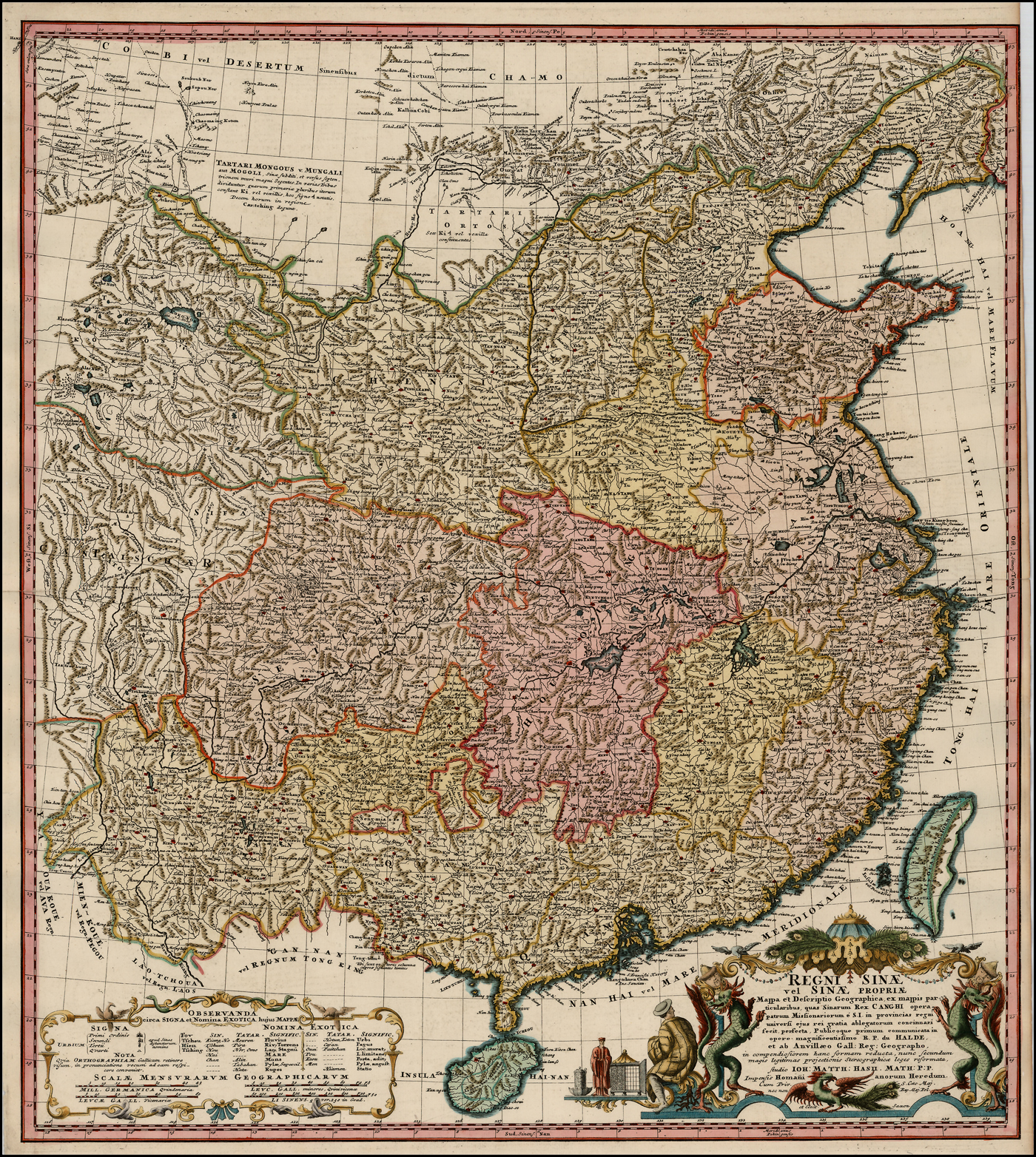
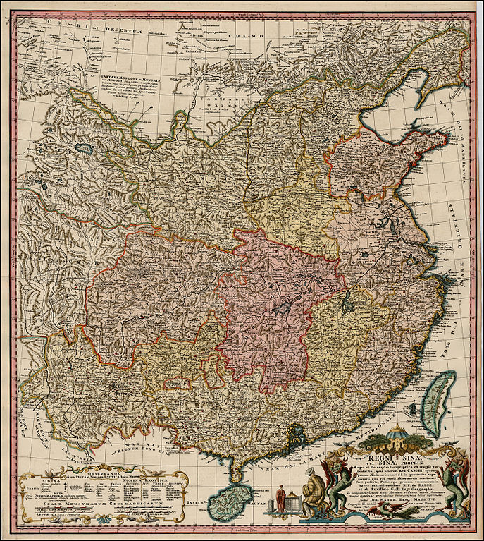
English: A map of the "Kingdom of China or China Proper" Latina: Regni Sinae vel Sinae Propriae: Mappa et Descriptio Geographica ex Mappis Particularibus quas Sinarum Rex Canghi Opera Patrum Missionariorum e S.I. in Provincias Regni Universi ejus Rei Gratia Ablegatorum Concinnari Fecit Perfecta Publicoque Primum Communicata in Opere Magnificentissimo R.P. du Halde et ab Anvillaeo Gall. Reg. Geographo... Tiếng Việt: Bản đồ Trung Quốc thời nhà Thanh đầu triều Càn Long, những năm 1735-1740. Johann M. Haas tạo ra dựa trên các tác phẩm của Du Halder và D'Anville (Jean Baptiste Bourguignon d'Anville, 1697-1782). |
|||||
| Date | ||||||
| Source | https://www.raremaps.com/gallery/archivedetail/2188/Regni_Sinae_vel_Sinae_Propriae_Mappa_et_Descriptio_Gegraphica_ex_mappis/Haas.html | |||||
| Author | Johann Matthaus Haas, R.P. Du Halde, Jean Baptiste Bourguignon d'Anville | |||||
| Permission (Reusing this file) |
|
|||||
| Other versions | ||||||
File history
Click on a date/time to view the file as it appeared at that time.
| Date/Time | Thumbnail | Dimensions | User | Comment | |
|---|---|---|---|---|---|
| current | 20:40, 3 April 2014 | | 1,400 × 1,564 (3.29 MB) | Doãn Hiệu (talk | contribs) | {{Information |Description ={{vi|1=Bản đồ Trung Quốc thời nhà Thanh đầu triều Càn Long, những năm 1735-1740. Johann M. Haas tạo ra dựa trên các tác phẩm của Du Halder và D'Anville (Jean Baptiste Bourguignon d'Anville,... |
You cannot overwrite this file.
File usage on Commons
The following 13 pages use this file:
- File:1735 Homann Heirs Map of China.jpg
- File:1740 map of China, published by Homann Heirs.jpg
- File:1740 map of China, published by Homannsche Erben.jpg
- File:Anville Nouvel atlas de la Chine - Page18 Chine generale assemble.jpg
- File:BienGioiVietTrung1740.jpg
- File:Ca. 1740 map of China, published by Homann Heirs.jpg
- File:Ca. 1740 map of China, published by Homannsche Erben.jpg
- File:Carte générale de la Chine Dressée sur les Cartes particulières que l'Empereur Cang-hi a fait lever sur les lieux par les RR. PP. Jésuites missionaires dans cet empire - Par le S(ieu)r d'Anville, geographe... - btv1b530092343.jpg
- File:Carte générale de la Chine Dressée sur les Cartes particulières que l'Empereur Cang-hi a fait lever sur les lieux par les RR. PP. Jésuites missionaires dans cet empire - Par le Sr. d'Anville... ; gravé par... - btv1b53027484v.jpg
- File:Carte générale de la Chine Dressée sur les Cartes particulières que l'Empereur Cang-hi a fait lever sur les lieux par les RR. PP. Jésuites missionaires dans cet empire - Par le Sr. d'Anville... ; gravé par... - btv1b530274859.jpg
- File:Carte générale de la Chine Dressée sur les Cartes particulières que l'Empereur Cang-hi a fait lever sur les lieux par les RR. PP. Jésuites missionaires dans cet empire - Par le Sr. d'Anville... ; gravé par... - btv1b530938432.jpg
- File:Carte générale de la Chine Dressée sur les Cartes particulières que l'Empereur Cang-hi a fait lever sur les lieux par les RR. PP. Jésuites missionaires dans cet empire - Par le Sr d'Anville... 1000 Lys ou... - btv1b59627166.jpg
- File:Nouvel Atlas de la Chine, de la Tartarie chinoise et du Thibet contenant les cartes générales et particulières de ces pays, ainsi que la carte du royaume de Corée, la plupart levées sur les lieux... - btv1b53096745m (021 of 117).jpg
r_d%27Anville,_geographe..._-_btv1b530092343.jpg)
.jpg)
File usage on other wikis
The following other wikis use this file:
- Usage on en.wiktionary.org
- Usage on la.wikipedia.org
- Usage on vi.wikipedia.org
- Usage on zh.wiktionary.org