File:China map.svg

Size of this PNG preview of this SVG file: 616 × 553 pixels. Other resolutions: 267 × 240 pixels | 535 × 480 pixels | 856 × 768 pixels | 1,141 × 1,024 pixels | 2,281 × 2,048 pixels.
Original file (SVG file, nominally 616 × 553 pixels, file size: 224 KB)
File information
Structured data
Captions
Captions
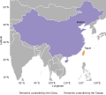
The territories actually controlled by the People's Republic of China (purple) and the Republic of China (orange).
中華人民共和國(紫色)與中華民國(橘色)實際控制的領土。
Summary
edit| DescriptionChina map.svg |
English: The territories actually controlled by the People's Republic of China (purple) and the Republic of China (orange).
The territorial waters off Fujian are specifically marked as controlled by the Republic of China, but not all islands in the waters off Fujian are controlled by the Republic of China. Islands and reefs in the South China Sea are not all marked, only those controlled respectively by the People's Republic of China and the Republic of China are indicated.
中文(臺灣):中華人民共和國(紫色)與中華民國(橘色)實際控制的領土。
福建外海特別標示中華民國所控制領土,但不表示所有福建外海島嶼皆由中華民國所控制。南海海域諸島礁並未被全部標示,僅標示出分別由中華人民共和國及中華民國實際控制之島嶼。 |
| Date | |
| Source | Own work |
| Author | Chen-Pan Liao |
| SVG development InfoField | This image was created with Inkscape. This file uses embedded text that can be easily translated using a text editor. |
R code
editlibrary("rnaturalearth")
library("rnaturalearthdata")
library(ggplot2)
library(extrafont)
loadfonts() # Liberation Sans
sessionInfo()
# R version 4.3.3 (2024-02-29 ucrt)
# Platform: x86_64-w64-mingw32/x64 (64-bit)
# Running under: Windows 10 x64 (build 19045)
#
# Matrix products: default
#
#
# locale:
# [1] LC_COLLATE=English_United States.utf8 LC_CTYPE=English_United States.utf8
# [3] LC_MONETARY=English_United States.utf8 LC_NUMERIC=C
# [5] LC_TIME=English_United States.utf8
#
# time zone: Asia/Taipei
# tzcode source: internal
#
# attached base packages:
# [1] stats graphics grDevices utils datasets methods base
#
# other attached packages:
# [1] extrafont_0.19 ggplot2_3.5.1 rnaturalearthdata_1.0.0 rnaturalearth_1.0.1
#
# loaded via a namespace (and not attached):
# [1] Matrix_1.6-5 gtable_0.3.5 jsonlite_1.8.8 dplyr_1.1.4 compiler_4.3.3
# [6] tidyselect_1.2.1 Rcpp_1.0.12 parallel_4.3.3 scales_1.3.0 lattice_0.22-6
# [11] R6_2.5.1 generics_0.1.3 classInt_0.4-10 sf_1.0-16 tibble_3.2.1
# [16] units_0.8-5 munsell_0.5.1 DBI_1.2.2 pillar_1.9.0 rlang_1.1.3
# [21] utf8_1.2.4 Rttf2pt1_1.3.12 terra_1.7-71 cli_3.6.2 withr_3.0.0
# [26] magrittr_2.0.3 class_7.3-22 digest_0.6.35 grid_4.3.3 rstudioapi_0.16.0
# [31] lifecycle_1.0.4 nlme_3.1-164 vctrs_0.6.5 KernSmooth_2.23-22 proxy_0.4-27
# [36] glue_1.7.0 farver_2.1.1 extrafontdb_1.0 codetools_0.2-20 ape_5.8
# [41] fansi_1.0.6 e1071_1.7-14 colorspace_2.1-0 httr_1.4.7 tools_4.3.3
# [46] pkgconfig_2.0.3
world <- ne_countries(scale = "medium", returnclass = "sf")
islands <-
data.frame(
y = c(22.656938135472696, 22.053955753375806, 23.573864416271437, 26.368375734950668,26.22390394376239,
26.1541118784575, 25.957498600291473, 24.456809469124664, 24.431784235720272, 20.70240624955278,
10.377254484771324, 10.38541642954576,
#
9.6432749998578, 9.925727385335414, 10.928052552023521, 8.864922456447362, 10.207104308708276,
9.71495178703929, 9.908743881274654, 16.53431109232499, 15.78338615348698, 16.668072305405857,
15.15979124885287),
x = c(121.48693688520929, 121.54227393236144, 119.60316316550613, 120.49006525178886, 119.98444621280261,
119.93203256418563, 119.97874208352493, 118.39954051479884, 118.23880835819251, 116.72616701558418,
114.36515228360948, 114.41339086837809,
#
112.97502441054232, 115.50849302067317, 114.07355306346844, 112.83052462436527, 114.22351755408815,
114.28656161110732, 114.49672046256076, 111.60717210694975, 111.2013009843816, 112.7298503820263,
117.763015440141),
nation = c("Taiwan" |> rep(12),
"China" |> rep(11))
)
capital <-
data.frame(
y = c(39.902607468694846, 25.039983287087757),
x = c(116.40840251966281, 121.51233952920676),
name = c("Beijing", "Taipei")
)
ggplot(data = world) +
geom_sf(color = 'white', fill = gray(0.7)) +
geom_sf(color = 'white', mapping = aes(fill = name), data = subset(world, name %in% c("China", "Taiwan"))) +
geom_point(data = islands, mapping = aes(color = nation, x = x, y = y), show.legend = F, size = 1) +
geom_point(data = capital, mapping = aes(x = x, y = y), show.legend = F, size = 2, shape = 15) +
geom_text(data = capital, mapping = aes(x = x, y = y, label = name), show.legend = F, size = 12/72*25.4, hjust = -0, vjust = -1) +
coord_sf(xlim = c(75, 133), ylim = c(10, 52)) +
scale_fill_manual("", values = c("#f1a340", "#998ec3") |> rev(),
labels = paste("Territories controlled by the", c("PRC", "ROC"))) +
scale_color_manual("", values = c("#f1a340", "#998ec3") |> rev(),
labels = paste("Territories controlled by the", c("PRC", "ROC"))) +
ylab("Latitude") + xlab("Longitude") +
theme_minimal(base_size = 12, base_family = "Liberation Sans") +
theme(legend.position = "bottom",
panel.border = element_rect(fill = NA),
axis.text = element_text(size = 12, color = 1),
axis.ticks = element_line(color = 1),
panel.grid = element_blank(),
legend.text = element_text(size = 12, color = 1),
)
ggsave("China map.svg", width = 7, height = 7)
Licensing
editI, the copyright holder of this work, hereby publish it under the following license:
| This file is made available under the Creative Commons CC0 1.0 Universal Public Domain Dedication. | |
| The person who associated a work with this deed has dedicated the work to the public domain by waiving all of their rights to the work worldwide under copyright law, including all related and neighboring rights, to the extent allowed by law. You can copy, modify, distribute and perform the work, even for commercial purposes, all without asking permission.
http://creativecommons.org/publicdomain/zero/1.0/deed.enCC0Creative Commons Zero, Public Domain Dedicationfalsefalse |
File history
Click on a date/time to view the file as it appeared at that time.
| Date/Time | Thumbnail | Dimensions | User | Comment | |
|---|---|---|---|---|---|
| current | 08:18, 8 May 2024 |  | 616 × 553 (224 KB) | Chen-Pan Liao (talk | contribs) | optimize and fix typos |
| 09:45, 7 May 2024 |  | 616 × 553 (852 KB) | Chen-Pan Liao (talk | contribs) | Reverted to version as of 07:48, 7 May 2024 (UTC) | |
| 09:45, 7 May 2024 |  | 616 × 553 (859 KB) | Chen-Pan Liao (talk | contribs) | fix | |
| 07:48, 7 May 2024 |  | 616 × 553 (852 KB) | Chen-Pan Liao (talk | contribs) | Typos | |
| 07:38, 7 May 2024 |  | 616 × 553 (852 KB) | Chen-Pan Liao (talk | contribs) | Uploaded own work with UploadWizard |
You cannot overwrite this file.
File usage on Commons
The following page uses this file:
Metadata
This file contains additional information such as Exif metadata which may have been added by the digital camera, scanner, or software program used to create or digitize it. If the file has been modified from its original state, some details such as the timestamp may not fully reflect those of the original file. The timestamp is only as accurate as the clock in the camera, and it may be completely wrong.
| Width | 492.49pt |
|---|---|
| Height | 442.36pt |