File:Chokurei, Kanan, Santō, Sansei ryokō endōzu LOC 92682896-8.tif

Size of this JPG preview of this TIF file: 708 × 600 pixels. Other resolutions: 283 × 240 pixels | 567 × 480 pixels | 907 × 768 pixels | 1,209 × 1,024 pixels | 2,418 × 2,048 pixels | 6,879 × 5,826 pixels.
Original file (6,879 × 5,826 pixels, file size: 114.66 MB, MIME type: image/tiff)
Captions
Captions
Add a one-line explanation of what this file represents
Summary edit
| Description |
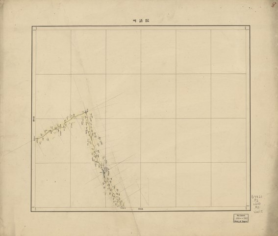
English: Shows topography, rivers, towns, villages, roads in 4 provinces of eastern China, including Zhili (present Beijing, Tianjin, Hebei, and western Liaoning), Henan, Shandong, and Shanxi, especially southwest Beijing area of Baoding, Taihang Mountain. Also shows military installations. Relief shown by hachures. Pen-and-ink and watercolor. Sheets separately subtitled with place names, e.g. Pekin (Peking). Available also through the Library of Congress Web site as a raster image. Index map on verso. ARP |
||
| Title | Chokurei, Kanan, Santō, Sansei ryokō endōzu | ||
| Shelf ID | G7821.P2 s200 .M3 | ||
| Parent | https://www.loc.gov/resource/g7821pm.gct00306/ | ||
| Sheet title | Sheet 8 | ||
| Date | |||
| Source | https://www.loc.gov/item/92682896/ | ||
| Author | Makino, Tomegor | ||
| Permission (Reusing this file) |
|
||
| Other versions |
|
||
| Location | China | ||
| Part of | American Memory · Catalog · Transportation And Communication · Geography And Map Division | ||
| Subject | Roads · Maps · China · Strategic Aspects · Maps, Manuscript |


Licensing edit
|
This is a faithful photographic reproduction of a two-dimensional, public domain work of art. The work of art itself is in the public domain for the following reason:
The official position taken by the Wikimedia Foundation is that "faithful reproductions of two-dimensional public domain works of art are public domain".
This photographic reproduction is therefore also considered to be in the public domain in the United States. In other jurisdictions, re-use of this content may be restricted; see Reuse of PD-Art photographs for details. | ||||
File history
Click on a date/time to view the file as it appeared at that time.
| Date/Time | Thumbnail | Dimensions | User | Comment | |
|---|---|---|---|---|---|
| current | 20:56, 2 July 2018 |  | 6,879 × 5,826 (114.66 MB) | Fæ (talk | contribs) | LOC Maps multisheet https://www.loc.gov/item/92682896/ sheet 8 of 29 #1160 |
You cannot overwrite this file.
File usage on Commons
The following page uses this file: