File:Christchurch Map.png

Size of this preview: 800 × 348 pixels. Other resolutions: 320 × 139 pixels | 640 × 279 pixels | 1,024 × 446 pixels | 2,100 × 914 pixels.
Original file (2,100 × 914 pixels, file size: 1.48 MB, MIME type: image/png)
Captions
Captions
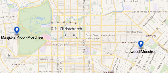
Location of the Christchurch mosques involved in the terrorist attack on March 2019
Summary
edit
| Description |
Deutsch: Lage der Moscheen des Terroranschlags English: Location of the Christchurch mosques involved in the terrorist attack on March 2019 |
| Date | |
| Source | Own work modified file from wmflabs |
| Author | Partynia |
Licensing
edit
I, the copyright holder of this work, hereby publish it under the following license:
This file is licensed under the Creative Commons Attribution-Share Alike 4.0 International license.
- You are free:
- to share – to copy, distribute and transmit the work
- to remix – to adapt the work
- Under the following conditions:
- attribution – You must give appropriate credit, provide a link to the license, and indicate if changes were made. You may do so in any reasonable manner, but not in any way that suggests the licensor endorses you or your use.
- share alike – If you remix, transform, or build upon the material, you must distribute your contributions under the same or compatible license as the original.
File history
Click on a date/time to view the file as it appeared at that time.
| Date/Time | Thumbnail | Dimensions | User | Comment | |
|---|---|---|---|---|---|
| current | 16:06, 11 May 2024 | | 2,100 × 914 (1.48 MB) | Kiwiz1338 (talk | contribs) | Reverted to version as of 11:02, 15 March 2019 (UTC) |
| 15:42, 16 March 2019 |  | 2,100 × 914 (1.49 MB) | Partynia (talk | contribs) | +Hospital | |
| 11:02, 15 March 2019 |  | 2,100 × 914 (1.48 MB) | Partynia (talk | contribs) | User created page with UploadWizard |
You cannot overwrite this file.
File usage on Commons
The following 2 pages use this file:
File usage on other wikis
The following other wikis use this file:
- Usage on de.wikipedia.org
- Usage on it.wikipedia.org
- Usage on nl.wikipedia.org
- Usage on nl.wikinews.org
- Usage on sv.wikipedia.org
- Usage on uk.wikipedia.org
- Usage on www.wikidata.org