File:Church Lane, Rochdale, Lancashire - geograph.org.uk - 344675.jpg
No higher resolution available.
Church_Lane,_Rochdale,_Lancashire_-_geograph.org.uk_-_344675.jpg (640 × 474 pixels, file size: 101 KB, MIME type: image/jpeg)
Captions
Captions
Add a one-line explanation of what this file represents
Summary
edit
| Description |
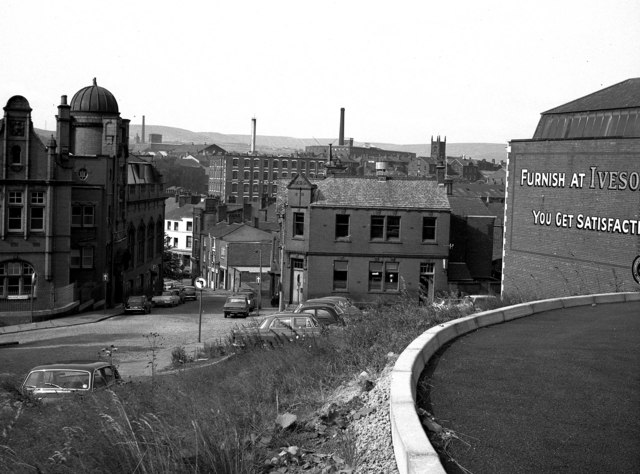
English: Church Lane, Rochdale, Lancashire Church Lane is a very old road that runs down from the Parish Church to the Town Centre. Here we see the lower part of the street. The road it crosses is Nelson Street, with the Deaf and Dumb Institute on the right hand corner. The large building on the left of Church Street houses the Technical School, (it also contained the Boys High School until 1953). Kelsall and Kemp's Butts Mill fills the centre background, while St. James' Church tower is seen to the right. |
| Date | |
| Source | From geograph.org.uk |
| Author | Dr Neil Clifton |
| Attribution (required by the license) | Dr Neil Clifton / Church Lane, Rochdale, Lancashire / |
| Camera location | | View this and other nearby images on: OpenStreetMap |
|---|
_heading:0.00&language=en)
| Object location | | View this and other nearby images on: OpenStreetMap |
|---|
_heading:0.00&language=en)
Licensing
edit

|
This image was taken from the Geograph project collection. See this photograph's page on the Geograph website for the photographer's contact details. The copyright on this image is owned by Dr Neil Clifton and is licensed for reuse under the Creative Commons Attribution-ShareAlike 2.0 license.
|
This file is licensed under the Creative Commons Attribution-Share Alike 2.0 Generic license.
Attribution: Dr Neil Clifton
- You are free:
- to share – to copy, distribute and transmit the work
- to remix – to adapt the work
- Under the following conditions:
- attribution – You must give appropriate credit, provide a link to the license, and indicate if changes were made. You may do so in any reasonable manner, but not in any way that suggests the licensor endorses you or your use.
- share alike – If you remix, transform, or build upon the material, you must distribute your contributions under the same or compatible license as the original.
File history
Click on a date/time to view the file as it appeared at that time.
| Date/Time | Thumbnail | Dimensions | User | Comment | |
|---|---|---|---|---|---|
| current | 16:50, 2 January 2011 | | 640 × 474 (101 KB) | GeographBot (talk | contribs) | == {{int:filedesc}} == {{Information |description={{en|1=Church Lane, Rochdale, Lancashire Church Lane is a very old road that runs down from the Parish Church to the Town Centre. Here we see the lower part of the street. The road it crosses is Nelson S |
You cannot overwrite this file.
File usage on Commons
There are no pages that use this file.