File:Circuito Permanente del Jarama.svg

Size of this PNG preview of this SVG file: 800 × 582 pixels. Other resolutions: 320 × 233 pixels | 640 × 466 pixels | 1,024 × 745 pixels | 1,280 × 932 pixels | 2,560 × 1,863 pixels | 1,312 × 955 pixels.
Original file (SVG file, nominally 1,312 × 955 pixels, file size: 34 KB)
Captions
Captions
Add a one-line explanation of what this file represents
Summary edit
| Description |
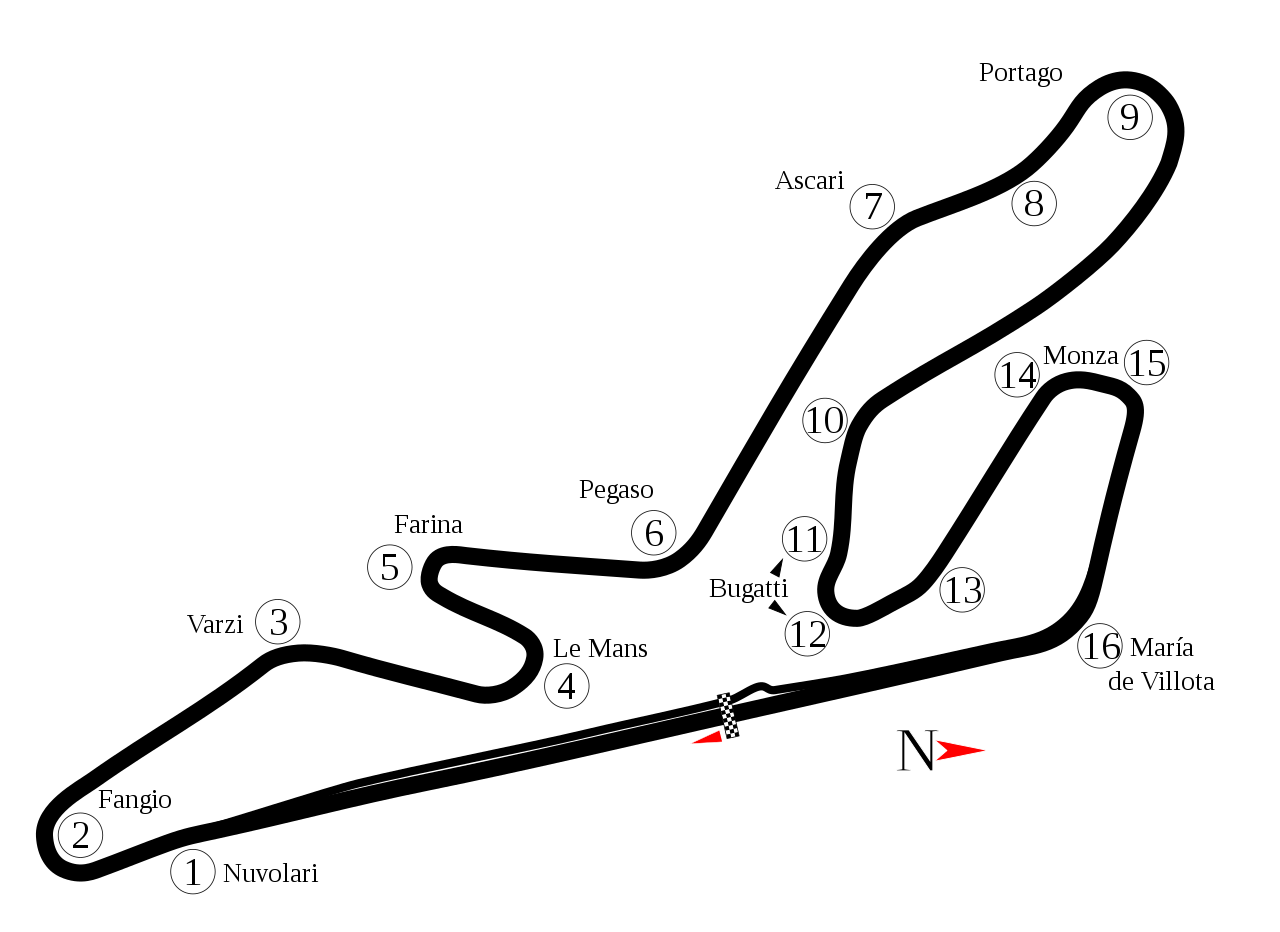
English: Track map of Circuito Permanente del Jarama. Note: The image listed below shows a section of track that doesn't appear in Google Earth. It is possible that section has been removed. |
| Date | |
| Source | Own work |
| Author | Will Pittenger |
| Other versions |
|

| Camera location | | View this and other nearby images on: OpenStreetMap |
|---|
Licensing edit
| I, the copyright holder of this work, release this work into the public domain. This applies worldwide. In some countries this may not be legally possible; if so: I grant anyone the right to use this work for any purpose, without any conditions, unless such conditions are required by law. |
File history
Click on a date/time to view the file as it appeared at that time.
| Date/Time | Thumbnail | Dimensions | User | Comment | |
|---|---|---|---|---|---|
| current | 19:30, 9 September 2021 | | 1,312 × 955 (34 KB) | Guadarrama1913 (talk | contribs) | 2017 update + minor changes |
| 10:56, 30 September 2013 |  | 1,312 × 955 (31 KB) | Sentoan (talk | contribs) | Mistake at T2 | |
| 10:54, 30 September 2013 |  | 1,312 × 955 (31 KB) | Sentoan (talk | contribs) | Real dimensions of the track, correct turn names, | |
| 02:43, 18 July 2008 |  | 1,312 × 955 (33 KB) | Will Pittenger (talk | contribs) | {{Information |Description={{en|1=Track map of w:Circuito Permanente del Jarama. Note: The image listed below shows a section of track that doesn't appear in Google Earth. It is possible that section has been removed.}} |Source=Own work by uploader |
You cannot overwrite this file.
File usage on Commons
The following 6 pages use this file:
File usage on other wikis
The following other wikis use this file:
- Usage on af.wikipedia.org
- Usage on ar.wikipedia.org
- Usage on ast.wikipedia.org
- Usage on bn.wikipedia.org
- Usage on ca.wikipedia.org
- Usage on de.wikipedia.org
- Usage on en.wikipedia.org
- Circuito del Jarama
- 2006 1000 km of Jarama
- 2001 ELMS at Jarama
- 1991 European motorcycle Grand Prix
- 1993 FIM motorcycle Grand Prix
- 1997 International Sports Racing Series Jarama
- 2002 FIA GT Jarama 500km
- 2001 FIA GT Jarama 500km
- 1996 BPR 4 Hours of Jarama
- List of Superbike World Championship circuits
- User talk:Chubbennaitor/archive2
- European motorcycle Grand Prix
- User talk:Barkjon/Archive 2
- Wikipedia:WikiProject Formula One/Newsletter/200808
- User talk:Hellboy2hell/archive2
- User talk:NapHit/Archive 1
- User talk:4u1e/archive5
- List of Grand Prix motorcycle circuits
- User talk:Typ932/Archive 3
- User talk:Midgrid/Archive 6
- 1998 Madrid motorcycle Grand Prix
- User talk:Thelb4/Archive 5
- User talk:Chubbennaitor/Archive7
- User talk:Readro/Archive 3
- User talk:Donnie Park/Archive 1
- User talk:The359/Archive 4
- List of Superleague Formula circuits
- 2009 Jarama Superleague Formula round
- List of American Le Mans Series circuits
- List of European Le Mans Series circuits
- User talk:Cs-wolves/Archive 3
- User talk:Bam123456789/Archive 1
- 2010 Jarama Superleague Formula round
- 1000 km Jarama
- User talk:Sage Callahan/Archive 1
- User talk:Cdhaptomos/Archive 1
- User talk:Spenalzo/Archive/2008
- User talk:Clyde1998/Archive/2008
View more global usage of this file.