File:Circular walk from Solva to St Elvis and Dinas Fawr (2) - geograph.org.uk - 1532646.jpg

Original file (557 × 640 pixels, file size: 156 KB, MIME type: image/jpeg)
Captions
Captions
Summary
edit_-_geograph.org.uk_-_1532646.jpg&action=edit§ion=1)
| Description |
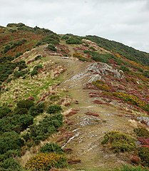
English: Circular walk from Solva to St Elvis and Dinas Fawr (2) This series of photos portrays a 2-mile circular walk east and south of Solva, Pembrokeshire.
Initially, the walk climbs out of the valley of the River Solva onto The Gribbin, a knife-edge ridge between the glacial valleys of Solva and Gwadn. The walk then descends to a marshy area before climbing inland to farmland. Near St Elvis Farm, the walk passes a cromlech (a neolithic burial chamber) then heads to the coastpath and turns west to follow the clifftop. After descending into Gwadn cove, the walk climbs to rejoin The Gribbin before descending into Solva. The route can be followed on OS 1:50000 sheet 157 or on OS 'Explorer' 1:25000 sheet OL35. Having climbed out of the Solva valley, the path emerges on The Gribbin ridge. The walk continues northeast along this clear footpath along the top of the ridge. Previous [1] Next [2] |
| Date | |
| Source | From geograph.org.uk |
| Author | Andy F |
| Attribution (required by the license) | Andy F / Circular walk from Solva to St Elvis and Dinas Fawr (2) / |
| Camera location | | View this and other nearby images on: OpenStreetMap |
|---|
_-_geograph.org.uk_-_1532646.jpg¶ms=051.872630_N_-005.187800_E_globe:Earth_type:camera_source:geograph-osgb36(SM80652414)_heading:45.00&language=en)
| Object location | | View this and other nearby images on: OpenStreetMap |
|---|
_-_geograph.org.uk_-_1532646.jpg¶ms=051.873010_N_-005.187200_E_globe:Earth_class:object_type:object_source:geograph-osgb36(SM80692418)_heading:45.00&language=en)
Licensing
edit_-_geograph.org.uk_-_1532646.jpg&action=edit§ion=2)

|
This image was taken from the Geograph project collection. See this photograph's page on the Geograph website for the photographer's contact details. The copyright on this image is owned by Andy F and is licensed for reuse under the Creative Commons Attribution-ShareAlike 2.0 license.
|
- You are free:
- to share – to copy, distribute and transmit the work
- to remix – to adapt the work
- Under the following conditions:
- attribution – You must give appropriate credit, provide a link to the license, and indicate if changes were made. You may do so in any reasonable manner, but not in any way that suggests the licensor endorses you or your use.
- share alike – If you remix, transform, or build upon the material, you must distribute your contributions under the same or compatible license as the original.
File history
Click on a date/time to view the file as it appeared at that time.
| Date/Time | Thumbnail | Dimensions | User | Comment | |
|---|---|---|---|---|---|
| current | 06:05, 3 March 2011 | | 557 × 640 (156 KB) | GeographBot (talk | contribs) | == {{int:filedesc}} == {{Information |description={{en|1=Circular walk from Solva to St Elvis and Dinas Fawr (2) This series of photos portrays a 2-mile circular walk east and south of Solva, Pembrokeshire. Initially, the walk climbs out of the valley |
You cannot overwrite this file.
File usage on Commons
There are no pages that use this file.
_-_geograph.org.uk_-_1532646.jpg&oldid=861222986)