File:CityPlace, Toronto, Ontario from CN Tower (21840091275).jpg

Original file (3,930 × 2,950 pixels, file size: 6.51 MB, MIME type: image/jpeg)
Captions
Captions
Summary
edit.jpg&action=edit§ion=1)
| Description |
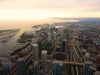
CityPlace is a neighbourhood in Downtown Toronto, Canada, within the former Railway Lands. When completed, this area will be the largest residential development ever created in Toronto. The area is bordered by Bathurst Street to the west, Lake Shore Boulevard to the south, and Front Street to the north and Blue Jays Way and the Rogers Centre to the east. Cityplace is also a 5- to 10-minute walk from King Street West and Liberty Village and a 10- to 20-minute walk from Toronto's financial district. The neighbourhood is also home to the Canoe Landing Park designed by famed Canadian writer and artist Douglas Coupland. What is now CityPlace was originally conceived as a way to revitalize what was Canadian National's former Spadina Street Yard Facility, which was part of the extensive Railway Lands in the waterfront area. Going as far back as 1965, when CN began to shift the functions of many of its yards in the Greater Toronto Area to a centralized facility in the northern suburb of Vaughan, there had been plans to revitalize this part of downtown. One of them called for the construction of a large television/telecommunications tower as a showcase of Canadian industry, which was realized in the 1970s with the CN Tower in addition to the massive Metro Centre which was later cancelled. Further development took place in the 1980s, with the 1984 completion of the Metro Toronto Convention Centre drawing new attention to the area. With the arrival of new visitors and development of new commercial draws, a fresh master plan was drawn up by the City of Toronto for revitalization of this area. At the same time Via Rail, the sole remaining occupant of the Spadina Street Yards, relocated their local operations to the newly built Toronto Maintenance Centre in New Toronto, freeing up the lands necessary for the planned revitalization. Work commenced after the demolition of the last railway buildings with the construction of SkyDome, which was completed in 1989. At the same time, a new network of roads, parks and infrastructure began to take shape. The project proceeded smoothly until an economic downturn caused many of the development plans to be shelved, and much land stood abandoned until 1997 when construction of the Air Canada Centre arena commenced. This began the third and final phase of redevelopment called CityPlace which called for a multipupose development of commercial, residential, and retail along the western section of the Railway Lands. en.wikipedia.org/wiki/CityPlace,_Toronto en.wikipedia.org/wiki/Wikipedia:Text_of_Creative_Commons_... |
| Date | Taken on 28 September 2015, 15:24 |
| Source | CityPlace, Toronto, Ontario from CN Tower |
| Author | Ken Lund from Reno, Nevada, USA |
| Camera location | | View this and other nearby images on: OpenStreetMap |
|---|
.jpg¶ms=043.642419_N_-079.387259_E_globe:Earth_type:camera_source:Flickr_&language=en)
Licensing
edit.jpg&action=edit§ion=2)
- You are free:
- to share – to copy, distribute and transmit the work
- to remix – to adapt the work
- Under the following conditions:
- attribution – You must give appropriate credit, provide a link to the license, and indicate if changes were made. You may do so in any reasonable manner, but not in any way that suggests the licensor endorses you or your use.
- share alike – If you remix, transform, or build upon the material, you must distribute your contributions under the same or compatible license as the original.
| This image was originally posted to Flickr by Ken Lund at https://flickr.com/photos/75683070@N00/21840091275. It was reviewed on 19 December 2016 by FlickreviewR and was confirmed to be licensed under the terms of the cc-by-sa-2.0. |
File history
Click on a date/time to view the file as it appeared at that time.
| Date/Time | Thumbnail | Dimensions | User | Comment | |
|---|---|---|---|---|---|
| current | 15:32, 19 December 2016 | | 3,930 × 2,950 (6.51 MB) | Mindmatrix (talk | contribs) | Transferred from Flickr via Flickr2Commons |
You cannot overwrite this file.
File usage on Commons
There are no pages that use this file.
.jpg&oldid=861387864)