File:Civil War newspaper maps from the New York times and the New York herald LOC 2002626099-28.tif
Size of this JPG preview of this TIF file: 443 × 599 pixels. Other resolutions: 177 × 240 pixels | 355 × 480 pixels | 567 × 768 pixels | 757 × 1,024 pixels | 1,513 × 2,048 pixels | 4,666 × 6,314 pixels.
Original file (4,666 × 6,314 pixels, file size: 84.29 MB, MIME type: image/tiff)
Captions
Captions
Add a one-line explanation of what this file represents
Summary edit
| Description |
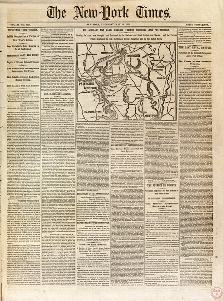
English: Issues of the New York times and the New York herald published between Sept. 5, 1861 and June 28, 1862, each with a front page map depicting a Civil War battle, campaign, or other related military event. Some issues have 2 maps on the front page or maps on other pages. Descriptive articles relating to the maps are printed on the sheets with the maps. Each newspaper issue consists of 8 pages. Relief shown by hachures on some maps. Title derived from dealer description. Some maps are indexed. Inventory in Geography & Map Division Reading Room. Available also through the Library of Congress Web site as a raster image. CW3 Acquisitions control no. 1994-12 |
||
| Title | [Civil War newspaper maps from the New York times and the New York herald]. | ||
| Shelf ID | G3701.S5 svar .C5 | ||
| Parent | https://www.loc.gov/resource/g3701sm.gcw1035000/ | ||
| Sheet title | NYT: Thurs., May 15, 1862 Military Advance Toward Richmond & Petersburg, VA | ||
| Date | |||
| Source | https://www.loc.gov/item/2002626099/ | ||
| Author | Unknown author | ||
| Permission (Reusing this file) |
|
||
| Other versions |
|
||
| Location | United States | ||
| Part of | Military Battles And Campaigns · American Memory · Civil War Maps · Catalog · Geography And Map Division | ||
| Subject | American Newspapers · Newspapers · Sections, Columns, Etc · Civil War · United States · Maps · Front Pages · History |


Licensing edit
|
This is a faithful photographic reproduction of a two-dimensional, public domain work of art. The work of art itself is in the public domain for the following reason:
The official position taken by the Wikimedia Foundation is that "faithful reproductions of two-dimensional public domain works of art are public domain".
This photographic reproduction is therefore also considered to be in the public domain in the United States. In other jurisdictions, re-use of this content may be restricted; see Reuse of PD-Art photographs for details. | ||||
File history
Click on a date/time to view the file as it appeared at that time.
| Date/Time | Thumbnail | Dimensions | User | Comment | |
|---|---|---|---|---|---|
| current | 02:30, 12 July 2018 |  | 4,666 × 6,314 (84.29 MB) | Fæ (talk | contribs) | LOC Maps multisheet https://www.loc.gov/item/2002626099/ sheet 28 of 32 #11008 |
You cannot overwrite this file.
File usage on Commons
The following page uses this file: