File:Civitatis imp Lindaviensis territorivm.jpg

Size of this preview: 752 × 599 pixels. Other resolutions: 301 × 240 pixels | 602 × 480 pixels | 964 × 768 pixels | 1,280 × 1,020 pixels | 2,560 × 2,041 pixels | 5,500 × 4,384 pixels.
Original file (5,500 × 4,384 pixels, file size: 2.37 MB, MIME type: image/jpeg)
Captions
Captions
Add a one-line explanation of what this file represents
| Description |
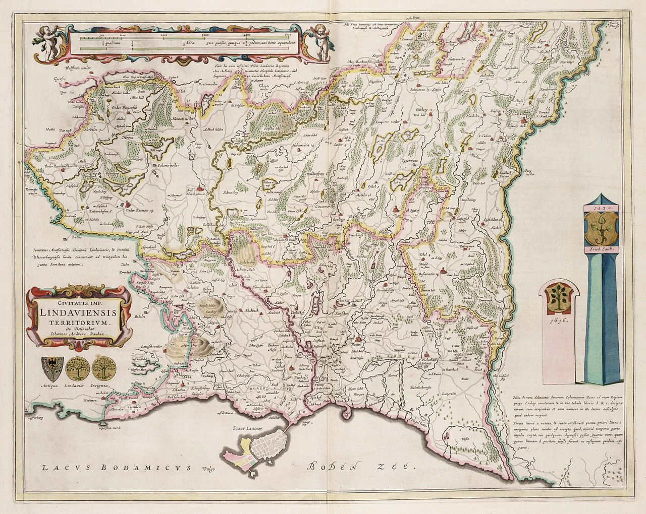
Deutsch: CIVITATIS IMP. LINDAVIENSIS TERRITORIVM. ita Delineabat Iohannes Andreas Rauhen, Amsterdam 1663 (Das Gebiet der Reichsstadt Lindau) |
| Date | |
| Source |
David Rumsey map collection https://resolver.kb.nl/resolve?urn=urn:gvn:NESA01:L02-0850 English: Map published in 1665 by Amsterdam geographer and map publisher Johannes Blaeu showing the territory of the Free Imperial City of Lindau ("Civitatis Imp. Lindaviensis Territorivm") on the shores of Lake Constance. The town of Lindau proper is located on the small offhore island at the bottom of the map. Politically, Lindau also ruled over a territory on the mainland. In the area bordered in pink, Lindau exercised full sovereignty, while in the area to the north, bordered in yellow, it shared sovereignty with the neighbouring counts of Monfort-Tettnang who exercised high jurisdiction (Hochgerichtsbarkeit), while Lindau exercised low jurisdiction (Niedergericht). A complementary map showing the northernmost tip of the territory not shown in the above map was also issued (see below). (Information taken from Werner Dobras, "Lindau, Reichsstadt" in: Historisches Lexikon Bayerns (04.10.2010). |
| Author | Johannes Blaeu; Johannes Andreas Rauhen |
| Other versions |
|

|
This work is in the public domain in its country of origin and other countries and areas where the copyright term is the author's life plus 100 years or fewer. | |
| This file has been identified as being free of known restrictions under copyright law, including all related and neighboring rights. | |
File history
Click on a date/time to view the file as it appeared at that time.
| Date/Time | Thumbnail | Dimensions | User | Comment | |
|---|---|---|---|---|---|
| current | 19:07, 13 January 2010 | | 5,500 × 4,384 (2.37 MB) | AndreasPraefcke (talk | contribs) | {{Information |Description=CIVITATIS IMP. LINDAVIENSIS TERRITORIVM. ita Delineabat Iohannes Andreas Rauhen, Amsterdam 1663 (Das Gebiet der Reichsstadt Lindau) |Source=http://www.geheugenvannederland.nl/?/en/items/NESA01:L02-0850 |Date=1663 |Author= Johan |
You cannot overwrite this file.
File usage on Commons
There are no pages that use this file.
File usage on other wikis
The following other wikis use this file:
- Usage on it.wikipedia.org