File:Cleared land, Belfast (1) - geograph.org.uk - 1320051.jpg
No higher resolution available.
Cleared_land,_Belfast_(1)_-_geograph.org.uk_-_1320051.jpg (632 × 374 pixels, file size: 98 KB, MIME type: image/jpeg)
Captions
Captions
Add a one-line explanation of what this file represents
Summary
edit_-_geograph.org.uk_-_1320051.jpg&action=edit§ion=1)
| Description |
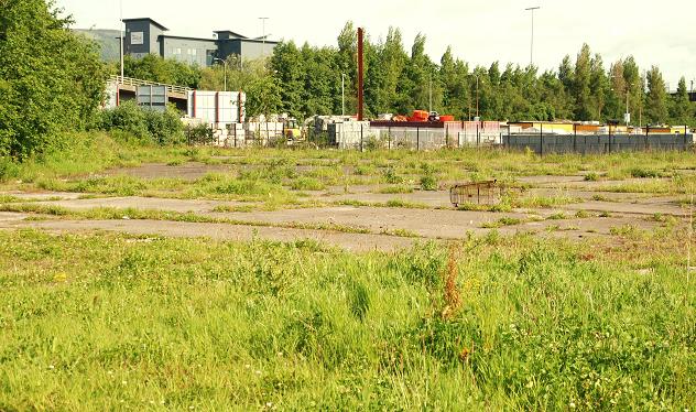
English: Cleared land, Belfast (1). The idea of an elevated ring road around central Belfast fully emerged in 1964. The scheme went as far as widespread demolition and clearance but the only elevated section built was what in now the M3 368340. The main part of the scheme - the Westlink joining the M1 634555 to the M2 272921 was built at ground level and had to be partly re-built with underpasses 498794.
The grade-separated junction at York Street 582043 and 582034 where the Westlink would join the M2 (to the north) and the M3 (to the east) remains un-built but the (very expensive) idea has been revived. This is part of the land (looking from Corporation Street to York Street) where there would be an interesting elevated junction. |
| Date | |
| Source | From geograph.org.uk |
| Author | Albert Bridge |
| Attribution (required by the license) | Albert Bridge / Cleared land, Belfast (1) / |
_-_geograph.org.uk_-_634555.jpg)
_-_geograph.org.uk_-_498794.jpg)
| Camera location | | View this and other nearby images on: OpenStreetMap |
|---|
_-_geograph.org.uk_-_1320051.jpg¶ms=054.606670_N_-005.922400_E_globe:Earth_type:camera_source:geograph-irishgrid(J34297514)_heading:337.00&language=en)
| Object location | | View this and other nearby images on: OpenStreetMap |
|---|
_-_geograph.org.uk_-_1320051.jpg¶ms=054.607030_N_-005.922700_E_globe:Earth_class:object_type:object_source:geograph-irishgrid(J34277518)_heading:337.00&language=en)
Licensing
edit_-_geograph.org.uk_-_1320051.jpg&action=edit§ion=2)

|
This image was taken from the Geograph project collection. See this photograph's page on the Geograph website for the photographer's contact details. The copyright on this image is owned by Albert Bridge and is licensed for reuse under the Creative Commons Attribution-ShareAlike 2.0 license.
|
This file is licensed under the Creative Commons Attribution-Share Alike 2.0 Generic license.
Attribution: Albert Bridge
- You are free:
- to share – to copy, distribute and transmit the work
- to remix – to adapt the work
- Under the following conditions:
- attribution – You must give appropriate credit, provide a link to the license, and indicate if changes were made. You may do so in any reasonable manner, but not in any way that suggests the licensor endorses you or your use.
- share alike – If you remix, transform, or build upon the material, you must distribute your contributions under the same or compatible license as the original.
File history
Click on a date/time to view the file as it appeared at that time.
| Date/Time | Thumbnail | Dimensions | User | Comment | |
|---|---|---|---|---|---|
| current | 20:31, 27 February 2011 | | 632 × 374 (98 KB) | GeographBot (talk | contribs) | == {{int:filedesc}} == {{Information |description={{en|1=Cleared land, Belfast (1) The idea of an elevated ring road around central Belfast fully emerged in 1964. The scheme went as far as widespread demolition and clearance but the only elevated section |
You cannot overwrite this file.
File usage on Commons
There are no pages that use this file.
_-_geograph.org.uk_-_1320051.jpg&oldid=943667415)