File:Clewbay.JPG
No higher resolution available.
Clewbay.JPG (640 × 480 pixels, file size: 111 KB, MIME type: image/jpeg)
Captions
Captions
Add a one-line explanation of what this file represents
Summary
edit
| Description |
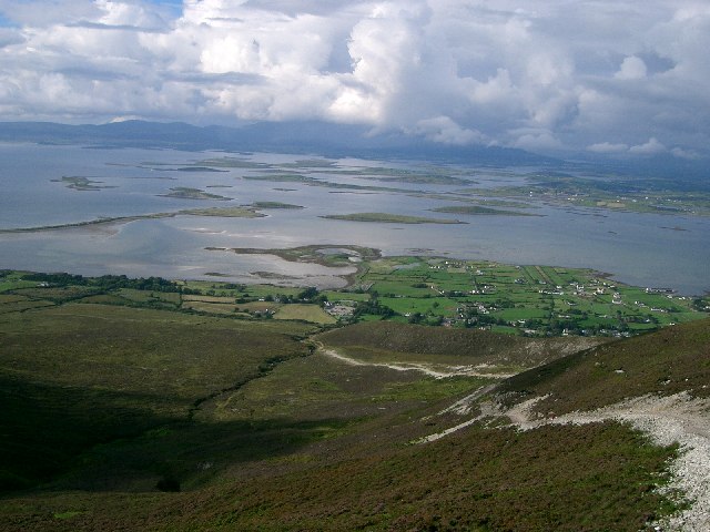
English: Clew Bay This photo taken from the slopes of Croagh Patrick shows Clew Bay and The Pilgrims Path. |
| Date | |
| Source | From geograph.org.uk |
| Author | Paul McIlroy |
| Attribution (required by the license) | Paul McIlroy / Clew Bay / |
| Camera location | | View this and other nearby images on: OpenStreetMap |
|---|
Licensing
edit

|
This image was taken from the Geograph project collection. See this photograph's page on the Geograph website for the photographer's contact details. The copyright on this image is owned by Paul McIlroy and is licensed for reuse under the Creative Commons Attribution-ShareAlike 2.0 license.
|
This file is licensed under the Creative Commons Attribution-Share Alike 2.0 Generic license.
Attribution: Paul McIlroy
- You are free:
- to share – to copy, distribute and transmit the work
- to remix – to adapt the work
- Under the following conditions:
- attribution – You must give appropriate credit, provide a link to the license, and indicate if changes were made. You may do so in any reasonable manner, but not in any way that suggests the licensor endorses you or your use.
- share alike – If you remix, transform, or build upon the material, you must distribute your contributions under the same or compatible license as the original.
File history
Click on a date/time to view the file as it appeared at that time.
| Date/Time | Thumbnail | Dimensions | User | Comment | |
|---|---|---|---|---|---|
| current | 18:22, 9 November 2008 | | 640 × 480 (111 KB) | File Upload Bot (Magnus Manske) (talk | contribs) | {{BotMoveToCommons|it.wikipedia}} {{Information |Description={{it|'''Panoramica della Baia di Clew'''<br> Al centro della foto è ben visibile la it:Baia di Clew, in Irlanda, e i vari ''it:drumlin'' che formano le |
You cannot overwrite this file.
File usage on Commons
There are no pages that use this file.
File usage on other wikis
The following other wikis use this file:
- Usage on cs.wikipedia.org
- Usage on it.wikipedia.org
- Usage on ru.wikipedia.org