File:Climbing towards Carn Pica - geograph.org.uk - 1106173.jpg
No higher resolution available.
Climbing_towards_Carn_Pica_-_geograph.org.uk_-_1106173.jpg (640 × 427 pixels, file size: 60 KB, MIME type: image/jpeg)
Captions
Captions
Add a one-line explanation of what this file represents
Summary
edit
| Description |
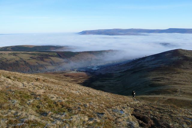
English: Climbing towards Carn Pica Nearing the top of the eastern slope of Carn Pica and looking back to the north-east. The north-western outliers of the Black Mountains, Mynydd Troed and Mynydd llangorse, can be seen in the distance. Closer to hand is Nant y Llanerch running down the centre towards Clydach, with Talybont Forest to the left and Twyn Du to the right. One of our party makes his way slowly up this steep climb, having lingered to take photos further down. |
| Date | |
| Source | From geograph.org.uk |
| Author | Graham Horn |
| Attribution (required by the license) | Graham Horn / Climbing towards Carn Pica / |
| Camera location | | View this and other nearby images on: OpenStreetMap |
|---|
_heading:67.00&language=en)
| Object location | | View this and other nearby images on: OpenStreetMap |
|---|
_heading:67.00&language=en)
Licensing
edit

|
This image was taken from the Geograph project collection. See this photograph's page on the Geograph website for the photographer's contact details. The copyright on this image is owned by Graham Horn and is licensed for reuse under the Creative Commons Attribution-ShareAlike 2.0 license.
|
This file is licensed under the Creative Commons Attribution-Share Alike 2.0 Generic license.
Attribution: Graham Horn
- You are free:
- to share – to copy, distribute and transmit the work
- to remix – to adapt the work
- Under the following conditions:
- attribution – You must give appropriate credit, provide a link to the license, and indicate if changes were made. You may do so in any reasonable manner, but not in any way that suggests the licensor endorses you or your use.
- share alike – If you remix, transform, or build upon the material, you must distribute your contributions under the same or compatible license as the original.
File history
Click on a date/time to view the file as it appeared at that time.
| Date/Time | Thumbnail | Dimensions | User | Comment | |
|---|---|---|---|---|---|
| current | 17:16, 24 February 2011 | | 640 × 427 (60 KB) | GeographBot (talk | contribs) | == {{int:filedesc}} == {{Information |description={{en|1=Climbing towards Carn Pica Nearing the top of the eastern slope of Carn Pica and looking back to the north-east. The north-western outliers of the Black Mountains, Mynydd Troed and Mynydd llangorse |
You cannot overwrite this file.
File usage on Commons
There are no pages that use this file.