File:Clydeview, near the shore at Levengrove - geograph.org.uk - 1073827.jpg
Clydeview,_near_the_shore_at_Levengrove_-_geograph.org.uk_-_1073827.jpg (640 × 427 pixels, file size: 81 KB, MIME type: image/jpeg)
Captions
Captions
Summary
edit
| Description |
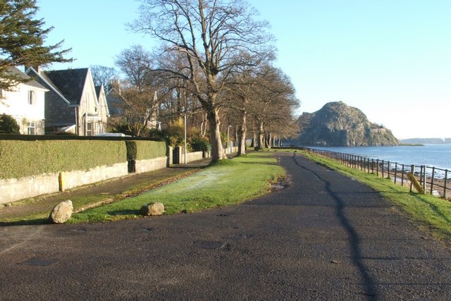
English: Clydeview, near the shore at Levengrove. This rather short row of houses is called Clydeview; the photograph was taken from the junction with Clydeshore Road.
(Specifically, it was taken from the same point at which some people and a car are located in the following photograph, which was taken while facing in the opposite direction: 795756.) Levengrove Park adjoins these houses on the north and on the east; following the pavement that recedes into the distance in this photograph leads to a gate into the park; a footpath there continues along the waterfront (793385), and passes a war memorial (793380). The volcanic plug of Dumbarton Rock is visible in the background. See also: 1073870. |
| Date | |
| Source | From geograph.org.uk |
| Author | Lairich Rig |
| Attribution (required by the license) | Lairich Rig / Clydeview, near the shore at Levengrove / |
_-_geograph.org.uk_-_1073870.jpg)
| Camera location | | View this and other nearby images on: OpenStreetMap |
|---|
_heading:90.00&language=en)
| Object location | | View this and other nearby images on: OpenStreetMap |
|---|
_heading:90.00&language=en)
Licensing
edit

|
This image was taken from the Geograph project collection. See this photograph's page on the Geograph website for the photographer's contact details. The copyright on this image is owned by Lairich Rig and is licensed for reuse under the Creative Commons Attribution-ShareAlike 2.0 license.
|
- You are free:
- to share – to copy, distribute and transmit the work
- to remix – to adapt the work
- Under the following conditions:
- attribution – You must give appropriate credit, provide a link to the license, and indicate if changes were made. You may do so in any reasonable manner, but not in any way that suggests the licensor endorses you or your use.
- share alike – If you remix, transform, or build upon the material, you must distribute your contributions under the same or compatible license as the original.
File history
Click on a date/time to view the file as it appeared at that time.
| Date/Time | Thumbnail | Dimensions | User | Comment | |
|---|---|---|---|---|---|
| current | 06:59, 24 February 2011 | | 640 × 427 (81 KB) | GeographBot (talk | contribs) | == {{int:filedesc}} == {{Information |description={{en|1=Clydeview, near the shore at Levengrove This rather short row of houses is called Clydeview; the photograph was taken from the junction with Clydeshore Road. (Specifically, it was taken from the |
You cannot overwrite this file.
File usage on Commons
There are no pages that use this file.