File:Coast path east from Cuddle - geograph.org.uk - 768429.jpg
No higher resolution available.
Coast_path_east_from_Cuddle_-_geograph.org.uk_-_768429.jpg (640 × 480 pixels, file size: 96 KB, MIME type: image/jpeg)
Captions
Captions
Add a one-line explanation of what this file represents
Summary edit
| Description |
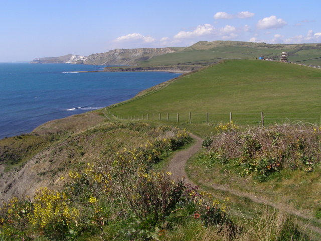
English: Coast path east from Cuddle The coast path leads along the crumbling cliff-top. Underfoot is the high ground of Cuddle. A seam of blackstone (oil shale) outcrops in the cliff below (off to the left) and on the left of this photo is a cutting that once carried the 1848 tramway of the Bituminous Shale Co. The tramway was connected to the workings north of D Plantation (off to the right), and from there it ran down towards a wooden pier that stood off the old sea-wall beside Maple Ledge in Kimmeridge Bay. |
| Date | |
| Source | From geograph.org.uk |
| Author | Jim Champion |
| Attribution (required by the license) | Jim Champion / Coast path east from Cuddle / |
| Camera location | | View this and other nearby images on: OpenStreetMap |
|---|
_heading:292.00&language=en)
| Object location | | View this and other nearby images on: OpenStreetMap |
|---|
_heading:292.00&language=en)
Licensing edit

|
This image was taken from the Geograph project collection. See this photograph's page on the Geograph website for the photographer's contact details. The copyright on this image is owned by Jim Champion and is licensed for reuse under the Creative Commons Attribution-ShareAlike 2.0 license.
|
This file is licensed under the Creative Commons Attribution-Share Alike 2.0 Generic license.
Attribution: Jim Champion
- You are free:
- to share – to copy, distribute and transmit the work
- to remix – to adapt the work
- Under the following conditions:
- attribution – You must give appropriate credit, provide a link to the license, and indicate if changes were made. You may do so in any reasonable manner, but not in any way that suggests the licensor endorses you or your use.
- share alike – If you remix, transform, or build upon the material, you must distribute your contributions under the same or compatible license as the original.
File history
Click on a date/time to view the file as it appeared at that time.
| Date/Time | Thumbnail | Dimensions | User | Comment | |
|---|---|---|---|---|---|
| current | 18:02, 19 February 2011 | | 640 × 480 (96 KB) | GeographBot (talk | contribs) | == {{int:filedesc}} == {{Information |description={{en|1=Coast path east from Cuddle The coast path leads along the crumbling cliff-top. Underfoot is the high ground of Cuddle. A seam of blackstone (oil shale) outcrops in the cliff below (off to the left) |
You cannot overwrite this file.
File usage on Commons
There are no pages that use this file.