File:Cohasset.jpg

Original file (4,627 × 3,142 pixels, file size: 2.95 MB, MIME type: image/jpeg)
Captions
Captions
Summary
edit|
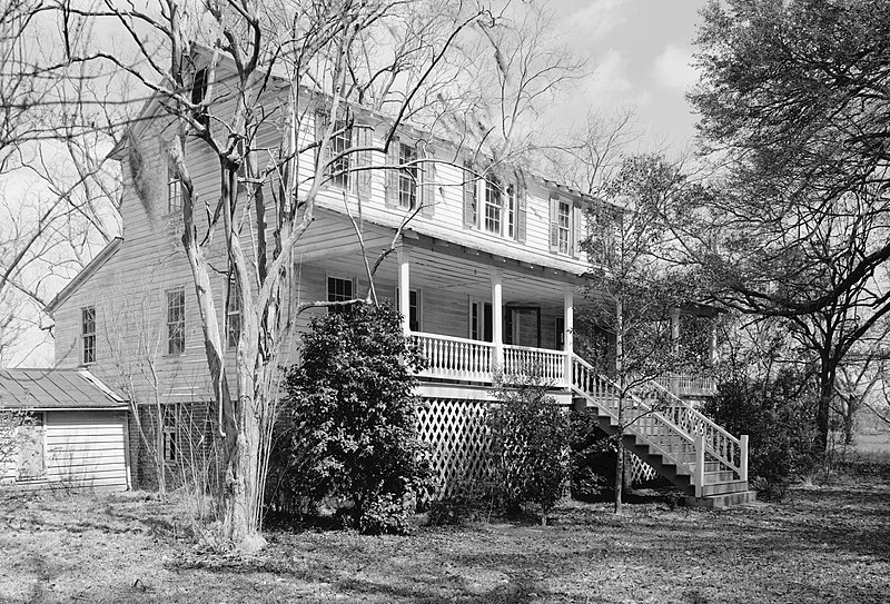
This is an image of a place or building that is listed on the National Register of Historic Places in the United States of America. Its reference number is 86001935. |
| Description |
English: Cohasset, US 601, 1 mile North of Crocketville, Crocketville vicinity, Hampton County, SC. SOUTHEAST (FRONT) AND SOUTHWEST SIDE ELEVATIONS, LOOKING EAST. (From HABS: Built in 1873. Significance: Excellent example of Carolina I house, a vernacular house type popular from the late 18th through the early 20th century. Associated with William James Gooding, a cotton farmer who played a locally important role in politics and government. In addition, the property, which includes several late 19th century outbuildings and a late 19th century tenant house, is significant for information it reveals about post-Civil War agricultural practices.) |
|||||||||||||||||||||||||
| Date | ||||||||||||||||||||||||||
| Source |
Historic American Buildings Survey,Library of Congress, Prints & Photographs Division, HABS [or HAER or HALS], Reproduction number "HABS SC,25-CROV.V,1-4"
|
|||||||||||||||||||||||||
| Author |
|
|||||||||||||||||||||||||
| Permission (Reusing this file) |
|
|||||||||||||||||||||||||


| Object location | | View this and other nearby images on: OpenStreetMap |
|---|
File history
Click on a date/time to view the file as it appeared at that time.
| Date/Time | Thumbnail | Dimensions | User | Comment | |
|---|---|---|---|---|---|
| current | 17:24, 26 March 2009 | | 4,627 × 3,142 (2.95 MB) | Martin H. (talk | contribs) | High res; cropped |
| 20:48, 10 October 2008 |  | 935 × 648 (580 KB) | Altairisfar (talk | contribs) | == Summary == {{Information |Description={{en|Cohasset, US 601, 1 mile North of Crocketville, Crocketville vicinity, Hampton County, SC. SOUTHEAST (FRONT) AND SOUTHWEST SIDE ELEVATIONS, LOOKING EAST. (From HABS: Built in 1873. Significance: Excellent ex |
You cannot overwrite this file.
File usage on Commons
The following page uses this file:
File usage on other wikis
The following other wikis use this file:
- Usage on en.wikipedia.org
- Usage on es.wikipedia.org
- Usage on fa.wikipedia.org
- Usage on it.wikipedia.org
- Usage on www.wikidata.org