File:Col des Maures et Capu Tafunatu depuis Ciuttulu.jpg

Size of this preview: 800 × 450 pixels. Other resolutions: 320 × 180 pixels | 640 × 360 pixels | 1,024 × 576 pixels | 1,280 × 720 pixels | 1,920 × 1,080 pixels.
Original file (1,920 × 1,080 pixels, file size: 1,018 KB, MIME type: image/jpeg)
Captions
Captions
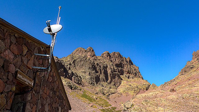
The Col des Maures pass (Bocca a i Mori) and Capu Tafunatu mountain, seen from the Ciuttulu di i Mori refuge
Summary
edit
| Description |
English: In the background are the Capu Tafunatu mountain and the Col des Maures pass to its right. In the foreground, the wall of the Ciuttulu di i Mori refuge supports both radio and satellite antennas used for emergency situations. |
| Date | |
| Source | Own work |
| Author | Cardioceras |
| Camera location | | View this and other nearby images on: OpenStreetMap |
|---|
Licensing
edit
I, the copyright holder of this work, hereby publish it under the following license:
This file is licensed under the Creative Commons Attribution-Share Alike 4.0 International license.
- You are free:
- to share – to copy, distribute and transmit the work
- to remix – to adapt the work
- Under the following conditions:
- attribution – You must give appropriate credit, provide a link to the license, and indicate if changes were made. You may do so in any reasonable manner, but not in any way that suggests the licensor endorses you or your use.
- share alike – If you remix, transform, or build upon the material, you must distribute your contributions under the same or compatible license as the original.
File history
Click on a date/time to view the file as it appeared at that time.
| Date/Time | Thumbnail | Dimensions | User | Comment | |
|---|---|---|---|---|---|
| current | 15:22, 1 March 2021 | | 1,920 × 1,080 (1,018 KB) | Cardioceras (talk | contribs) | Uploaded own work with UploadWizard |
You cannot overwrite this file.
File usage on Commons
The following page uses this file:
File usage on other wikis
The following other wikis use this file:
- Usage on fr.wikipedia.org