File:Colorado River Delta (MODIS 2016-09-25).jpg

Size of this preview: 646 × 600 pixels. Other resolutions: 259 × 240 pixels | 517 × 480 pixels | 828 × 768 pixels | 1,103 × 1,024 pixels | 1,446 × 1,342 pixels.
Original file (1,446 × 1,342 pixels, file size: 215 KB, MIME type: image/jpeg)
Captions
Captions
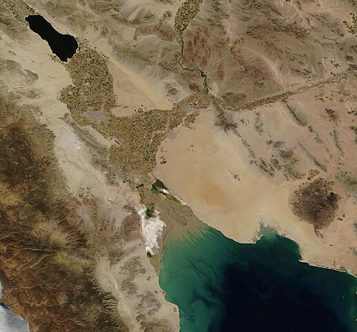
The Moderate Resolution Imaging Spectroradiometer (MODIS) aboard NASA’s Terra satellite captured a true-color image of the Colorado River Delta on September 19, 2016.
Summary
edit.jpg&action=edit§ion=1)
| Description |
English: Less than 100 years ago the Colorado River flowed freely from La Poudre Pass in Colorado over 1,450 miles (2334 km), crossing seven U.S. and two Mexican states before pouring into the Gulf of California via an ecologically rich delta. Over time the precious water carried by the Colorado River has been interrupted by a series of dams and diverted for crop irrigation and residential use. In the last decade, it has been estimated that only about ten percent of all water that flows into the Colorado makes it into Mexico and most of that is used for farming. The waters of the Colorado River have not reached the Gulf of California on a regular basis since 1960, creating a muddy, nearly barren, river delta.
A recent amendment to the water treaty between Mexico and the United States is working to improve the state of the southern Colorado River and renew the delta region. In 2014, a “pulse flow” of water was released from the Morelos Dam to mimic a spring flood. “Base flows”, which are smaller and more frequent than the pulse flow, are also intermittently released. As a result, the delta has begun to become greener, although it will likely never be restored to its historic richness. The Moderate Resolution Imaging Spectroradiometer (MODIS) aboard NASA’s Terra satellite captured a true-color image of the Colorado River Delta on September 19, 2016. The Colorado River can be clearly seen twisting through the arid lands of the southwest United States in the north central section of the image. The water-filled river channel comes to an abrupt end at the Morelos Dam, located on the border of the United States and Mexico. South of the dam the channel disappears into a spreading, green-tinged delta. Copious tan sediment is carried into the Gulf of California. |
||
| Date | Taken on 18 September 2016 | ||
| Source |
Colorado River Delta (direct link)
|
||
| Author | Jeff Schmaltz, MODIS Land Rapid Response Team, NASA GSFC |
| This media is a product of the Terra mission Credit and attribution belongs to the mission team, if not already specified in the "author" row |
Licensing
edit.jpg&action=edit§ion=2)
| This file is in the public domain in the United States because it was solely created by NASA. NASA copyright policy states that "NASA material is not protected by copyright unless noted". (See Template:PD-USGov, NASA copyright policy page or JPL Image Use Policy.) | ||
 |
Warnings:
|
File history
Click on a date/time to view the file as it appeared at that time.
| Date/Time | Thumbnail | Dimensions | User | Comment | |
|---|---|---|---|---|---|
| current | 19:19, 15 February 2024 | | 1,446 × 1,342 (215 KB) | OptimusPrimeBot (talk | contribs) | #Spacemedia - Upload of http://modis.gsfc.nasa.gov/gallery/images/image09252016_250m.jpg via Commons:Spacemedia |
You cannot overwrite this file.
File usage on Commons
There are no pages that use this file.
.jpg&oldid=852066768)