File:Columbia Glacier, Side View of Calving terminus, August 27, 1963 (GLACIERS 1052).jpg

Size of this preview: 607 × 600 pixels. Other resolutions: 243 × 240 pixels | 486 × 480 pixels | 778 × 768 pixels | 1,037 × 1,024 pixels | 2,073 × 2,048 pixels | 3,917 × 3,869 pixels.
Original file (3,917 × 3,869 pixels, file size: 2.91 MB, MIME type: image/jpeg)
Captions
Captions
Add a one-line explanation of what this file represents
Summary edit
.jpg&action=edit§ion=1)
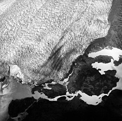
| English: Columbia Glacier, Side View of Calving terminus, August 27, 1963
( |
||||||||||||||||||||||||
|---|---|---|---|---|---|---|---|---|---|---|---|---|---|---|---|---|---|---|---|---|---|---|---|---|
| Photographer |
|
|||||||||||||||||||||||
| Title |
English: Columbia Glacier, Side View of Calving terminus, August 27, 1963 |
|||||||||||||||||||||||
| Description |
English: Columbia Glacier, Side View of Calving terminus, August 27, 1963
|
|||||||||||||||||||||||
| Depicted place | Columbia Glacier | |||||||||||||||||||||||
| Date | Taken on 27 August 1963 | |||||||||||||||||||||||
| Dimensions | height: 9 in (22.8 cm); width: 9 in (22.8 cm) | |||||||||||||||||||||||
| Collection |
|
|||||||||||||||||||||||
| Current location | ||||||||||||||||||||||||
| Accession number | ||||||||||||||||||||||||
| Source | ||||||||||||||||||||||||
| Permission (Reusing this file) |
|
|||||||||||||||||||||||
| Order Number | EAS0198 | |||||||||||||||||||||||
| Reference Number on Photograph | AT-1916 | |||||||||||||||||||||||
| Judicial District | Valdez-Cordova | |||||||||||||||||||||||
| Mountain Range | Chugach Mountains | |||||||||||||||||||||||
| Object location | | View this and other nearby images on: OpenStreetMap |
|---|
.jpg¶ms=060.983611_N_-147.097222_E_globe:Earth_class:object_type:object__&language=en)
File history
Click on a date/time to view the file as it appeared at that time.
| Date/Time | Thumbnail | Dimensions | User | Comment | |
|---|---|---|---|---|---|
| current | 02:48, 8 June 2019 | | 3,917 × 3,869 (2.91 MB) | BMacZeroBot (talk | contribs) | Batch upload (Commons:Batch uploading/University of Washington Digital Collections) |
You cannot overwrite this file.
File usage on Commons
The following 4 pages use this file:
.jpg)
.jpg&oldid=865278344)