File:Conformal Conic with Tissot's Indicatrices of Distortion.svg

Size of this PNG preview of this SVG file: 800 × 408 pixels. Other resolutions: 320 × 163 pixels | 640 × 326 pixels | 1,024 × 522 pixels | 1,280 × 652 pixels | 2,560 × 1,304 pixels | 1,600 × 815 pixels.
Original file (SVG file, nominally 1,600 × 815 pixels, file size: 599 KB)
Captions
Captions
Add a one-line explanation of what this file represents
Summary
edit
| Description |
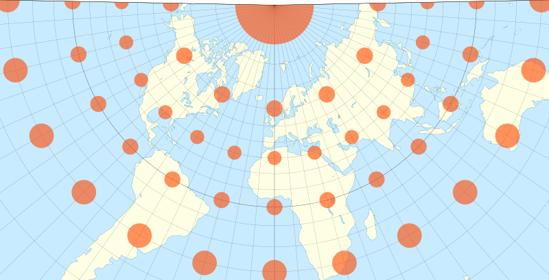
English: The world on a Lambert conformal conic projection, with 10° graticule and Tissot's indicatrices overlaid. Standard parallels are at 45°N and 15°N. Each red circle is 1,000 km in diameter. Coastline data from www.naturalearthdata.com. Colors inspired by Eric Gaba. Projection generated with my own code, at github.com/jkunimune15/Map-Projections. |
| Date | |
| Source | Own work |
| Author | Justin Kunimune |
Licensing
edit
I, the copyright holder of this work, hereby publish it under the following license:
This file is licensed under the Creative Commons Attribution-Share Alike 4.0 International license.
- You are free:
- to share – to copy, distribute and transmit the work
- to remix – to adapt the work
- Under the following conditions:
- attribution – You must give appropriate credit, provide a link to the license, and indicate if changes were made. You may do so in any reasonable manner, but not in any way that suggests the licensor endorses you or your use.
- share alike – If you remix, transform, or build upon the material, you must distribute your contributions under the same or compatible license as the original.
File history
Click on a date/time to view the file as it appeared at that time.
| Date/Time | Thumbnail | Dimensions | User | Comment | |
|---|---|---|---|---|---|
| current | 21:03, 15 February 2018 | | 1,600 × 815 (599 KB) | Justinkunimune (talk | contribs) | User created page with UploadWizard |
You cannot overwrite this file.
File usage on Commons
There are no pages that use this file.
File usage on other wikis
The following other wikis use this file:
- Usage on de.wikipedia.org
- Usage on en.wikipedia.org
- Usage on et.wikipedia.org
- Usage on vi.wikipedia.org