File:Connecticut River from the Air.jpg

Size of this preview: 800 × 494 pixels. Other resolutions: 320 × 197 pixels | 640 × 395 pixels | 1,024 × 632 pixels | 1,280 × 790 pixels | 2,560 × 1,580 pixels | 6,000 × 3,702 pixels.
Original file (6,000 × 3,702 pixels, file size: 17.45 MB, MIME type: image/jpeg)
Captions
Captions
Add a one-line explanation of what this file represents
Summary
edit
| Description |
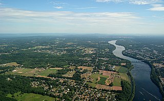
English: An aerial view of the Connecticut River in the U.S. state of Connecticut. The photograph is taken facing north; Suffield, CT is visible on the left bank and Thompsonville, CT on the right bank. The skyline of Springfield, Massachusetts is visible in the distance. |
| Date | |
| Source | https://www.flickr.com/photos/sonstroem/27958237863/ |
| Author | Eric Sonstroem |
Licensing
edit
This file is licensed under the Creative Commons Attribution 2.0 Generic license.
- You are free:
- to share – to copy, distribute and transmit the work
- to remix – to adapt the work
- Under the following conditions:
- attribution – You must give appropriate credit, provide a link to the license, and indicate if changes were made. You may do so in any reasonable manner, but not in any way that suggests the licensor endorses you or your use.
| This image was originally posted to Flickr by sonstroem at https://flickr.com/photos/96964826@N05/27958237863. It was reviewed on 30 November 2021 by FlickreviewR 2 and was confirmed to be licensed under the terms of the cc-by-2.0. |
File history
Click on a date/time to view the file as it appeared at that time.
| Date/Time | Thumbnail | Dimensions | User | Comment | |
|---|---|---|---|---|---|
| current | 23:01, 30 November 2021 | | 6,000 × 3,702 (17.45 MB) | Filetime (talk | contribs) | I changed the colors and light a bit |
| 22:56, 30 November 2021 |  | 6,000 × 3,702 (12.01 MB) | Filetime (talk | contribs) | Uploaded a work by Eric Sonstroem from https://www.flickr.com/photos/sonstroem/27958237863/ with UploadWizard |
You cannot overwrite this file.
File usage on Commons
There are no pages that use this file.
File usage on other wikis
The following other wikis use this file:
- Usage on en.wikipedia.org