File:Connecticut Street Armory, Connecticut Street, Front Park, Buffalo, NY - 52562405747.jpg

Size of this preview: 800 × 600 pixels. Other resolutions: 320 × 240 pixels | 640 × 480 pixels | 1,024 × 768 pixels | 1,280 × 960 pixels | 2,560 × 1,920 pixels | 3,810 × 2,857 pixels.
Original file (3,810 × 2,857 pixels, file size: 4.2 MB, MIME type: image/jpeg)
Captions
Captions
Add a one-line explanation of what this file represents
Summary
edit
| Description |
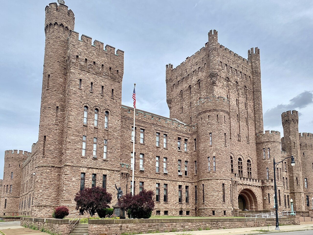
English: Built in 1899, this castle-like Richardsonian Romanesque Revival-style building was designed by Issac G. Perry and Captain William Lansing to house the 74th Regiment of the New York National Guard, replacing a water reservoir formerly located on the site. The building covers an entire city block bounded by Connecticut Street, Niagara Street, Vermont Street, and Prospect Avenue, dominating the north flank of Prospect Park and towering over the surrounding houses and apartment buildings, only being rivaled in size by the buildings of D’Youville University to the southeast and the D’Youville Porter Campus School on the south side of the park, though the building has the largest footprint and largest volume of any structure in the Front Park neighborhood of Buffalo, and is one of the largest structures in the city. The armory is approximately 240 feet wide and 550 feet long, consisting of a three-and-a-half-story office building at the south end, and a two-story drill shed at the north end, with several towers ranging in height from four to six stories lining the exterior, accentuating entrance locations, and standing at the corners of the building. The building features a red rusticated Medina Sandstone exterior, crenellated parapets, corbeling and machicolations, arched bays, circular and square towers, a hipped roof with skylights on the office portion of the building, low-slope roofs on the drill shed and towers, wide openings at the building’s major entrances, decorative copper lamp posts at the front steps atop sandstone piers, arrow slit windows, turrets, buttresses, and stone belt coursing. The building was listed on the National Register of Historic Places in 1995. |
| Date | |
| Source | https://www.flickr.com/photos/59081381@N03/52562405747/ |
| Author | w_lemay |
| Camera location | | View this and other nearby images on: OpenStreetMap |
|---|
Licensing
edit
This file is licensed under the Creative Commons Attribution-Share Alike 2.0 Generic license.
- You are free:
- to share – to copy, distribute and transmit the work
- to remix – to adapt the work
- Under the following conditions:
- attribution – You must give appropriate credit, provide a link to the license, and indicate if changes were made. You may do so in any reasonable manner, but not in any way that suggests the licensor endorses you or your use.
- share alike – If you remix, transform, or build upon the material, you must distribute your contributions under the same or compatible license as the original.
| This image was originally posted to Flickr by w_lemay at https://flickr.com/photos/59081381@N03/52562405747. It was reviewed on 14 March 2023 by FlickreviewR 2 and was confirmed to be licensed under the terms of the cc-by-sa-2.0. |
File history
Click on a date/time to view the file as it appeared at that time.
| Date/Time | Thumbnail | Dimensions | User | Comment | |
|---|---|---|---|---|---|
| current | 15:44, 14 March 2023 | | 3,810 × 2,857 (4.2 MB) | Ser Amantio di Nicolao (talk | contribs) | Uploaded a work by w_lemay from https://www.flickr.com/photos/59081381@N03/52562405747/ with UploadWizard |
You cannot overwrite this file.
File usage on Commons
There are no pages that use this file.