File:Continental scale carbon stocks of individual trees in African drylands (SVS5031).jpg

Size of this preview: 800 × 540 pixels. Other resolutions: 320 × 216 pixels | 640 × 432 pixels | 1,024 × 691 pixels | 1,280 × 864 pixels | 2,096 × 1,415 pixels.
Original file (2,096 × 1,415 pixels, file size: 1.83 MB, MIME type: image/jpeg)
Captions
Captions
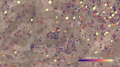
Using commercial, high-resolution satellite images and artificial intelligence, a team of NASA-funded scientists mapped almost 10 billion individual trees in Africa’s drylands in order to assess the amount of carbon stored outside of major forests.
Summary
edit| Description |
English: Using commercial, high-resolution satellite images and artificial intelligence, a team of NASA-funded scientists mapped almost 10 billion individual trees in Africa’s drylands in order to assess the amount of carbon stored outside of major forests. The result is the first comprehensive estimate of carbon density in the Saharan, Sahel, and Sudanian zones of Africa. Complete transcript available. |
| Date | 1 March 2023 (upload date) |
| Source | Continental scale carbon stocks of individual trees in African drylands |
| Author | NASA's Scientific Visualization Studio - Kel Elkins, Greg Shirah, Compton Tucker, Jesse R. Meyer, Martin Brandt, Kathleen Gaeta, Ian Jones, Laurence Schuler |
| Other versions |
|
| Keywords | Earth Science; Crown; Ecological Dynamics; Vegetation; Hyperwall; Biosphere; Biology; Ecology; Biomass |


.jpg&action=edit§ion=1)
Licensing
edit.jpg&action=edit§ion=2)
| This file is in the public domain in the United States because it was solely created by NASA. NASA copyright policy states that "NASA material is not protected by copyright unless noted". (See Template:PD-USGov, NASA copyright policy page or JPL Image Use Policy.) | ||
 |
Warnings:
|
File history
Click on a date/time to view the file as it appeared at that time.
| Date/Time | Thumbnail | Dimensions | User | Comment | |
|---|---|---|---|---|---|
| current | 13:19, 21 January 2024 | | 2,096 × 1,415 (1.83 MB) | OptimusPrimeBot (talk | contribs) | #Spacemedia - Upload of https://svs.gsfc.nasa.gov/vis/a000000/a005000/a005031/Untitled-1.jpg via Commons:Spacemedia |
You cannot overwrite this file.
File usage on Commons
The following 5 pages use this file:
- File:Continental scale carbon stocks of individual trees in African drylands (SVS5031 - carbon per tree legend).tiff
- File:Continental scale carbon stocks of individual trees in African drylands (SVS5031 - total carbon legend).tiff
- File:Continental scale carbon stocks of individual trees in African drylands (SVS5031 - tree counting carbon 1800).tiff
- File:Continental scale carbon stocks of individual trees in African drylands (SVS5031 - tree counting carbon 3000).tiff
- File:Continental scale carbon stocks of individual trees in African drylands (SVS5031 - tree counting carbon 4000).tiff
.jpg&oldid=867987261)