File:Cook Strait, New Zealand (MODIS 2019-06-06).jpg
Original file (2,082 × 1,573 pixels, file size: 1.01 MB, MIME type: image/jpeg)
Captions
Captions
Summary edit
.jpg&action=edit§ion=1)
| Description |
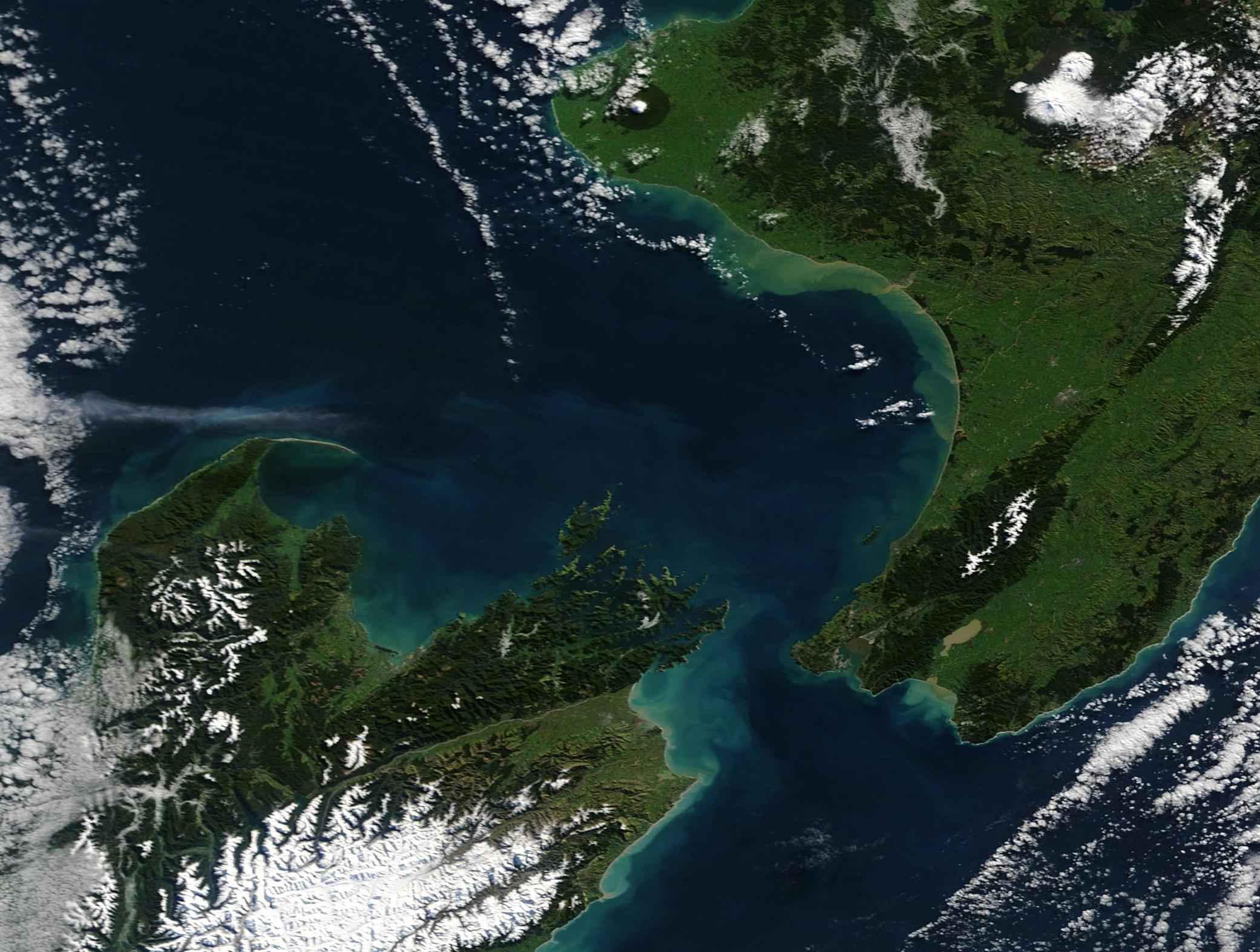
English: Approximately 20 miles (32 km) long and only 14 miles (22.5 km) wide at the narrowest point, the small Cook Strait remains a formidable body of water. The narrow strip of sea separating the North and South Islands of New Zealand has a reputation for being among the world’s roughest stretches of water. The two islands lie within the “Roaring Forties”, a belt of strong winds that circle the globe at about 40 degrees south. The gusting westerlies hit the islands and their mountainous terrain, and are forced into to the strait, which acts something like a huge wind tunnel. While ferries safely cross the Strait, on windy days the three-hour trip from Wellington Harbor, North Island, and Queen Charlotte Sound in the South Island has been described as “something like riding a bucking bronco”.
On May 3, 2019, the Moderate Resolution Imaging Spectroradiometer (MODIS) on board NASA’s Terra satellite acquired a true-color image of Cook Strait. The shorelines of both North Island and South Island are ringed with a halo of blues and greens—colors typical of sinking sediment. Sediment washed into water typically appears tan when it is near the surface then, as it sinks, the reflectance changes to make it appear either blue or green from space. The high waves and wind typical here contributes to shoreline erosion, resulting in turbid water. However, sediment may not be causing all of the color. The waters around New Zealand are rich in nutrients, so it is likely that phytoplankton are contributing to some of the fanciful swirls in the image, especially further from the shoreline. Mixing currents bring nutrients to the ocean’s surface, providing a prime environment for plankton blooms. Made up of millions of tiny plant-like organisms, the blooms routinely color the ocean with broad strokes of green and blue. |
||
| Date | Taken on 3 June 2019 | ||
| Source |
Cook Strait, New Zealand (direct link)
|
||
| Author | MODIS Land Rapid Response Team, NASA GSFC |
| This media is a product of the Terra mission Credit and attribution belongs to the mission team, if not already specified in the "author" row |
Licensing edit
.jpg&action=edit§ion=2)
| This file is in the public domain in the United States because it was solely created by NASA. NASA copyright policy states that "NASA material is not protected by copyright unless noted". (See Template:PD-USGov, NASA copyright policy page or JPL Image Use Policy.) | ||
 |
Warnings:
|
File history
Click on a date/time to view the file as it appeared at that time.
| Date/Time | Thumbnail | Dimensions | User | Comment | |
|---|---|---|---|---|---|
| current | 03:17, 17 February 2024 | | 2,082 × 1,573 (1.01 MB) | OptimusPrimeBot (talk | contribs) | #Spacemedia - Upload of http://modis.gsfc.nasa.gov/gallery/images/image06062019_250m.jpg via Commons:Spacemedia |
You cannot overwrite this file.
File usage on Commons
There are no pages that use this file.
.jpg&oldid=852712977)