File:Copthill Quarry - geograph.org.uk - 1562709.jpg

Size of this preview: 800 × 600 pixels. Other resolutions: 320 × 240 pixels | 640 × 480 pixels | 1,024 × 768 pixels.
Original file (1,024 × 768 pixels, file size: 135 KB, MIME type: image/jpeg)
Captions
Captions
Add a one-line explanation of what this file represents
Summary
edit
| Description |
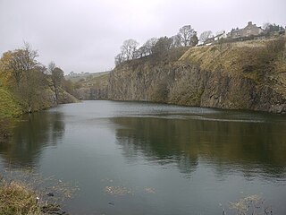
English: Copthill Quarry Disused and flooded quarry on the outcrop of the whin sill at Cowshill. The quarry was opened up in 1895 by Octavius Monkhouse who was the Innkeeper at the nearby Cowshill Inn and son of the local minister. The quarry is one of two whinstone quarries in Weardale, the other is at Stanhope, and rock was carted from the quarry to Wearhead railway station and from there down the dale for use in construction projects.
About 50 men worked the quarry in the early days and as it developed permission was obtained to demolish first the vicarage and then the church itself. Now only the graveyard remains, above the quarry, north west of Copthill Farm. By 1926 the quarry was in financial difficulties and closed down but a group of local men formed the Cowshill Quarry Company and this new company took over and continued the work up until final closure in 1943. http://www.aditnow.co.uk/mines/Copt-Hill-Whinstone-Quarry/ |
| Date | |
| Source | From geograph.org.uk |
| Author | Andrew Curtis |
| Attribution (required by the license) | Andrew Curtis / Copthill Quarry / |
| Camera location | | View this and other nearby images on: OpenStreetMap |
|---|
_heading:337.00&language=en)
| Object location | | View this and other nearby images on: OpenStreetMap |
|---|
_heading:337.00&language=en)
Licensing
edit

|
This image was taken from the Geograph project collection. See this photograph's page on the Geograph website for the photographer's contact details. The copyright on this image is owned by Andrew Curtis and is licensed for reuse under the Creative Commons Attribution-ShareAlike 2.0 license.
|
This file is licensed under the Creative Commons Attribution-Share Alike 2.0 Generic license.
Attribution: Andrew Curtis
- You are free:
- to share – to copy, distribute and transmit the work
- to remix – to adapt the work
- Under the following conditions:
- attribution – You must give appropriate credit, provide a link to the license, and indicate if changes were made. You may do so in any reasonable manner, but not in any way that suggests the licensor endorses you or your use.
- share alike – If you remix, transform, or build upon the material, you must distribute your contributions under the same or compatible license as the original.
File history
Click on a date/time to view the file as it appeared at that time.
| Date/Time | Thumbnail | Dimensions | User | Comment | |
|---|---|---|---|---|---|
| current | 06:26, 10 March 2023 | | 1,024 × 768 (135 KB) | Geograph Update Bot (talk | contribs) | Higher-resolution version from Geograph |
| 16:29, 3 March 2011 |  | 640 × 480 (73 KB) | GeographBot (talk | contribs) | == {{int:filedesc}} == {{Information |description={{en|1=Copthill Quarry Disused and flooded quarry on the outcrop of the whin sill at Cowshill. The quarry was opened up in 1895 by Octavius Monkhouse who was the Innkeeper at the nearby Cowshill Inn and so |
You cannot overwrite this file.
File usage on Commons
There are no pages that use this file.