File:Corfu topographic map-en librsvg.png

Size of this preview: 537 × 600 pixels. Other resolutions: 215 × 240 pixels | 430 × 480 pixels | 688 × 768 pixels | 917 × 1,024 pixels | 2,096 × 2,341 pixels.
Original file (2,096 × 2,341 pixels, file size: 2.1 MB, MIME type: image/png)
Captions
Captions
Add a one-line explanation of what this file represents
Summary edit
| Description |
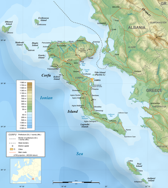
English: Topographic map in English of the Corfu island area in Greece.
Note : The shaded relief is a raster image embedded in the SVG file. Français : Carte topographique en anglais de la zone de l'île de Corfou en Grèce.
Note : Le relief ombré est une image bitmap embarquée dans le fichier SVG. UTM projection ; WGS84 datum ; shaded relief (composite image of N-W, W and N lightning positions) ;
|
|||
| PNG development | ||||
| Date | March 2007 (modified 09/2008) | |||
| Source |
|
|||
| Creator | ||||
| Permission (Reusing this file) |
|
|||
| Georeferencing | If inappropriate please set warp_status = skip to hide. | |||
| Other versions |
[]
|


Licensing edit
I, the copyright holder of this work, hereby publish it under the following licenses:

|
Permission is granted to copy, distribute and/or modify this document under the terms of the GNU Free Documentation License, Version 1.2 or any later version published by the Free Software Foundation; with no Invariant Sections, no Front-Cover Texts, and no Back-Cover Texts. A copy of the license is included in the section entitled GNU Free Documentation License. |
| This file is licensed under the Creative Commons Attribution-Share Alike 3.0 Unported license. | ||
| ||
| This licensing tag was added to this file as part of the GFDL licensing update. |
This file is licensed under the Creative Commons Attribution-Share Alike 2.5 Generic, 2.0 Generic and 1.0 Generic license.
- You are free:
- to share – to copy, distribute and transmit the work
- to remix – to adapt the work
- Under the following conditions:
- attribution – You must give appropriate credit, provide a link to the license, and indicate if changes were made. You may do so in any reasonable manner, but not in any way that suggests the licensor endorses you or your use.
- share alike – If you remix, transform, or build upon the material, you must distribute your contributions under the same or compatible license as the original.
You may select the license of your choice.
File history
Click on a date/time to view the file as it appeared at that time.
| Date/Time | Thumbnail | Dimensions | User | Comment | |
|---|---|---|---|---|---|
| current | 20:38, 23 March 2021 | | 2,096 × 2,341 (2.1 MB) | JoKalliauer (talk | contribs) | {{Information |Description= |Source= |Date= |Author= |Permission= |other_versions= }} |
You cannot overwrite this file.
File usage on Commons
The following 3 pages use this file:
File usage on other wikis
The following other wikis use this file:
- Usage on it.wikipedia.org