File:Cosos (Keeling) Islands (Australia) map.png
No higher resolution available.
Cosos_(Keeling)_Islands_(Australia)_map.png (329 × 355 pixels, file size: 6 KB, MIME type: image/png)
Captions
Captions
Add a one-line explanation of what this file represents
Summary
edit_Islands_(Australia)_map.png&action=edit§ion=1)
| Description |
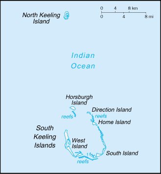
English: Map of Cocos (Keeling) Islands (Australia)
Italiano: Mappa delle isole Cocos e Keeling |
|||
| Date | ||||
| Source | https://www.cia.gov/library/publications/the-world-factbook/geos/ck.html | |||
| Author | Directorate of Intelligence, CIA | |||
| Permission (Reusing this file) |
|
Licensing
edit_Islands_(Australia)_map.png&action=edit§ion=2)
This image is in the public domain because it contains materials that originally came from the United States Central Intelligence Agency's World Factbook.
|
 |
Original upload log
edit_Islands_(Australia)_map.png&action=edit§ion=3)
| Date/Time | Dimensions | User | Comment |
|---|---|---|---|
| 16 March 2013, 17:32:28 | 329 × 355 (5923 bytes) | Edoardo Cavaleri (talk · contribs) | {{Information |Description ={{en|1=Map of Cocos (Keeling) Islands (Australia)}} {{it|1=Mappa delle isole Cocos e Keeling}} |Source =https://www.cia.gov/library/publications/the-world-factbook/geos/ck.html |Author =Directorate of Inte... |
File history
Click on a date/time to view the file as it appeared at that time.
| Date/Time | Thumbnail | Dimensions | User | Comment | |
|---|---|---|---|---|---|
| current | 12:24, 3 December 2014 | | 329 × 355 (6 KB) | GifTagger (talk | contribs) | Bot: Converting file to superior PNG file. (Source: Cosos_(Keeling)_Islands_(Australia)_map.gif). This GIF was problematic due to non-greyscale color table. |
_Islands_(Australia)_map.gif)
You cannot overwrite this file.
File usage on Commons
The following 2 pages use this file:
_Islands_(Australia)_map.gif&redirect=no)
File usage on other wikis
The following other wikis use this file:
- Usage on it.wikipedia.org
_Islands_(Australia)_map.png&oldid=868881543)