File:Cotahuasi Canyon oblique.jpg
Cotahuasi_Canyon_oblique.jpg (720 × 480 pixels, file size: 515 KB, MIME type: image/jpeg)
Captions
Captions
Summary edit
| Description |
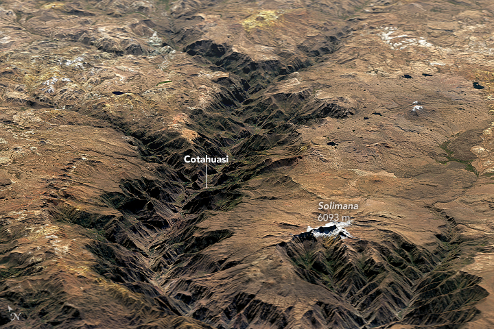
English: Cotahuasi Canyon in Peru stands as a potent reminder of the tremendous erosive power of water and ice. Cutting through a towering plateau—a product of repeated volcanic eruptions and tectonic uplift—the canyon is one of the deepest in the world.
Cotahuasi formed over the course of several million years as rivers and glaciers chiseled into the plateau. The relief from the canyon floor to the rim ranges from 2.5 to 3.5 kilometers (1.5 to 2.2 miles), making Cotahuasi Canyon about twice as deep as the Grand Canyon. On June 3, 2016, the Operational Land Imager (OLI) on Landsat 8 passed over the canyon. The top image shows Landsat data draped over topographic data from NASA’s Shuttle Radar Topography Mission (SRTM). The second image is a nadir (straight down) view from OLI of the area near the town of Cotahuasi. Evidence of volcanic activity surrounds the canyon. To the south, snow-capped Solimana, an inactive stratovolcano that last erupted about 500,000 years ago, soars above the plateau. Colorful yellow and orange volcanic deposits are visible around the north rim of the canyon. More info & refs at source URL |
|||||
| Date | ||||||
| Source | https://earthobservatory.nasa.gov/IOTD/view.php?id=91686&src=eoa-iotd | |||||
| Author | NASA Earth Observatory images by Joshua Stevens, using Landsat data from the U.S. Geological Survey. | |||||
| Permission (Reusing this file) |
|

File history
Click on a date/time to view the file as it appeared at that time.
| Date/Time | Thumbnail | Dimensions | User | Comment | |
|---|---|---|---|---|---|
| current | 22:59, 13 February 2018 | | 720 × 480 (515 KB) | Tillman (talk | contribs) | {{Information |Description ={{en|1=Cotahuasi Canyon in Peru stands as a potent reminder of the tremendous erosive power of water and ice. Cutting through a towering plateau—a product of repeated volcanic eruptions and tectonic uplift—the canyon... |
You cannot overwrite this file.
File usage on Commons
The following 2 pages use this file:
File usage on other wikis
The following other wikis use this file:
- Usage on en.wikipedia.org
- Usage on es.wikipedia.org
- Usage on fr.wikivoyage.org
- Usage on he.wikivoyage.org
- Usage on it.wikivoyage.org
- Usage on pl.wikipedia.org
- Usage on qu.wikipedia.org
- Usage on ru.wikipedia.org
- Usage on sv.wikipedia.org
- Usage on uk.wikipedia.org
- Usage on www.wikidata.org