File:CountryFair footprint map.png

Size of this preview: 800 × 525 pixels. Other resolutions: 320 × 210 pixels | 640 × 420 pixels | 1,017 × 667 pixels.
Original file (1,017 × 667 pixels, file size: 115 KB, MIME type: image/png)
Captions
Captions
Add a one-line explanation of what this file represents
Summary
edit
| Description |
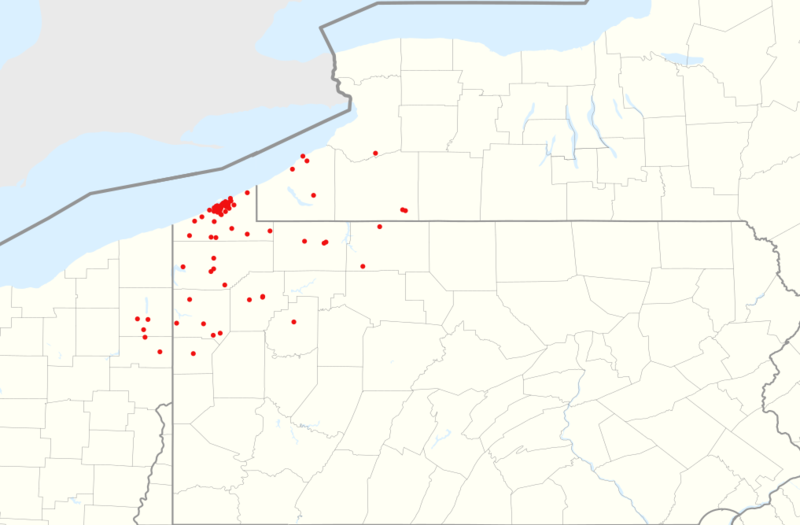
English: Geographic footprint of Country Fair's 72 convenience stores, as of 2 February 2021 companion map to File:CountryFair KwikFill 2020-01.png |
| Date | |
| Source |
This file was derived from: |
| Author |
| Point Maps
══▻ FAQ ◅══ ══▻ Create your own ◅══ |
Licensing
edit
| This work is ineligible for copyright and therefore in the public domain because it consists entirely of information that is common property and contains no original authorship. |
File history
Click on a date/time to view the file as it appeared at that time.
| Date/Time | Thumbnail | Dimensions | User | Comment | |
|---|---|---|---|---|---|
| current | 12:25, 2 February 2021 | | 1,017 × 667 (115 KB) | BoringJim (talk | contribs) | Uploaded own work with UploadWizard |
You cannot overwrite this file.
File usage on Commons
The following page uses this file:
File usage on other wikis
The following other wikis use this file:
- Usage on en.wikipedia.org