File:Courthouse Square as seen from Court Street Bridge, Owego, New York - 20220206.jpg

Size of this preview: 800 × 480 pixels. Other resolutions: 320 × 192 pixels | 1,024 × 614 pixels | 1,280 × 768 pixels | 2,560 × 1,536 pixels | 3,715 × 2,229 pixels.
Original file (3,715 × 2,229 pixels, file size: 2.07 MB, MIME type: image/jpeg)
Captions
Captions
Add a one-line explanation of what this file represents
Summary edit
| Description |
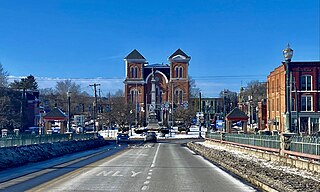
English: Courthouse Square in central Owego, New York, as seen from near the crest of the Court Street Bridge over the Susquehanna River on a February 2022 evening. The square has been the site of a public park dating back to 1797, only a few years after the village's incorporation, and it's today the central node of the historic downtown. In 1871, about half of the park was reclaimed by the municipal government to serve as the home of the Tioga County Courthouse, which was completed the following year to a design by locally-based architect Miles F. Howe and is seen at center in the photograph. Unusually for the Second Empire style, bluntly pointed arches are a recurring motif: you see them not only on the prominent limestone window heads above the double arched windows on the three-story towers that delineate the building's four corners, but also crowning the façade itself in the form of a raking cornice undergirded by block modillions. Even more unusual is the absence of a mansard roof, ordinarily the style's defining feature. The entrance, not visible from this perspective, is framed consecutively by a round arch of cut limestone and a shallow tetrastyle portico with stylized Corinthian pillars. The interior, too, is architecturally notable for its fine-quality woodwork, including chestnut wainscoting on the walls as well as window frames and furnishings in black walnut. In front rises the Tioga County Memorial, a 50-foot shaft of Barre granite crowned and flanked by depictions of Civil War soldiers and sailors, erected in 1890 to the memory of the local "heroes who fought, and martyrs who fell, that the Union might live". |
| Date | |
| Source | Own work |
| Author | Andre Carrotflower |
| Camera location | | View this and other nearby images on: OpenStreetMap |
|---|
Licensing edit
I, the copyright holder of this work, hereby publish it under the following license:
This file is licensed under the Creative Commons Attribution-Share Alike 4.0 International license.
- You are free:
- to share – to copy, distribute and transmit the work
- to remix – to adapt the work
- Under the following conditions:
- attribution – You must give appropriate credit, provide a link to the license, and indicate if changes were made. You may do so in any reasonable manner, but not in any way that suggests the licensor endorses you or your use.
- share alike – If you remix, transform, or build upon the material, you must distribute your contributions under the same or compatible license as the original.
File history
Click on a date/time to view the file as it appeared at that time.
| Date/Time | Thumbnail | Dimensions | User | Comment | |
|---|---|---|---|---|---|
| current | 02:33, 14 February 2022 | | 3,715 × 2,229 (2.07 MB) | Andre Carrotflower (talk | contribs) | Uploaded own work with UploadWizard |
You cannot overwrite this file.
File usage on Commons
There are no pages that use this file.
File usage on other wikis
The following other wikis use this file:
- Usage on en.wikipedia.org
- Usage on es.wikipedia.org
- Usage on sr.wikipedia.org