File:Craig projection SW.jpg

Size of this preview: 800 × 454 pixels. Other resolutions: 320 × 182 pixels | 640 × 363 pixels | 1,024 × 581 pixels | 1,280 × 727 pixels | 2,059 × 1,169 pixels.
Original file (2,059 × 1,169 pixels, file size: 575 KB, MIME type: image/jpeg)
Captions
Captions
Add a one-line explanation of what this file represents
|
Summary edit
| Description |
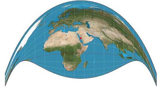
English: Part of the world on Craig retroazimuthal projection. 15° graticule, central meridian 39°49'E, center latitude 21°25'N (Mecca). Imagery is a derivative of NASA’s Blue Marble summer month composite with oceans lightened to enhance legibility and contrast. Image created with the Geocart map projection software. |
| Date | |
| Source | Own work |
| Author | Strebe |
Licensing edit
I, the copyright holder of this work, hereby publish it under the following license:
This file is licensed under the Creative Commons Attribution-Share Alike 3.0 Unported license.
- You are free:
- to share – to copy, distribute and transmit the work
- to remix – to adapt the work
- Under the following conditions:
- attribution – You must give appropriate credit, provide a link to the license, and indicate if changes were made. You may do so in any reasonable manner, but not in any way that suggests the licensor endorses you or your use.
- share alike – If you remix, transform, or build upon the material, you must distribute your contributions under the same or compatible license as the original.
File history
Click on a date/time to view the file as it appeared at that time.
| Date/Time | Thumbnail | Dimensions | User | Comment | |
|---|---|---|---|---|---|
| current | 22:20, 15 August 2011 | | 2,059 × 1,169 (575 KB) | Strebe (talk | contribs) |
You cannot overwrite this file.
File usage on Commons
There are no pages that use this file.
File usage on other wikis
The following other wikis use this file:
- Usage on ar.wikipedia.org
- Usage on de.wikipedia.org
- Usage on en.wikipedia.org
- User talk:Strebe
- Qibla
- Craig retroazimuthal projection
- Talk:Craig retroazimuthal projection
- Wikipedia:Featured pictures/Diagrams, drawings, and maps/Maps
- User talk:Cowtowner
- List of map projections
- Wikipedia:Featured pictures thumbs/35
- Wikipedia:Featured picture candidates/June-2013
- Wikipedia:Featured picture candidates/Map Projections Set
- Wikipedia:Picture of the day/August 2015
- Template:POTD/2015-08-19
- Wikipedia:Main Page history/2015 August 19
- Portal:Geography/Selected picture
- Wikipedia:Reference desk/Archives/Mathematics/2023 November 23
- Usage on es.wikipedia.org
- Usage on fr.wikipedia.org
- Usage on hi.wikipedia.org
- Usage on hu.wikipedia.org
- Usage on it.wikipedia.org
- Usage on ja.wikipedia.org
- Usage on ko.wikipedia.org
- Usage on ms.wikipedia.org
- Usage on nl.wikipedia.org
- Usage on pt.wikipedia.org
- Usage on ru.wikipedia.org
- Usage on uk.wikipedia.org
- Usage on uz.wikipedia.org
- Usage on www.wikidata.org
- Usage on zh.wikipedia.org