File:Cratons IT.svg

Size of this PNG preview of this SVG file: 800 × 546 pixels. Other resolutions: 320 × 218 pixels | 640 × 436 pixels | 1,024 × 698 pixels | 1,280 × 873 pixels | 2,560 × 1,746 pixels | 2,000 × 1,364 pixels.
Original file (SVG file, nominally 2,000 × 1,364 pixels, file size: 269 KB)
Captions
Captions
Add a one-line explanation of what this file represents
Summary
edit
| Description |
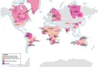
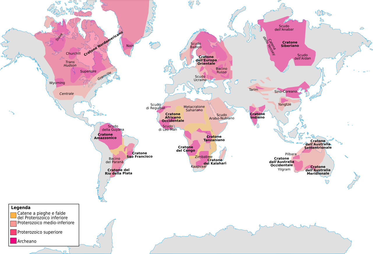
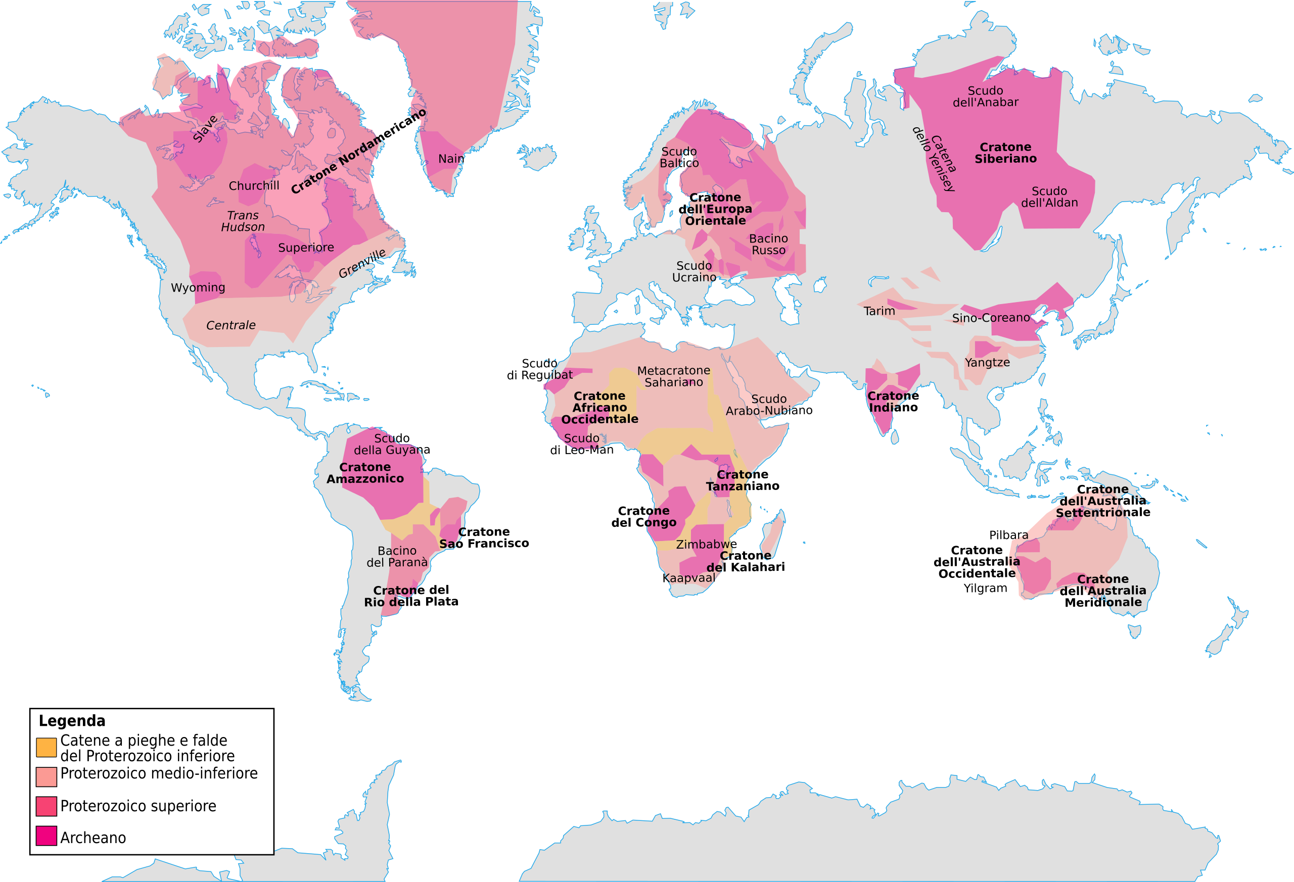
English: A simplified geologic map of the world, showing major proterozoic and archozoic crust sections.
Italiano: Carta geologica semplificata del mondo, sono indicati i principali blocchi crostali proterozoici e archeani. |
| Date | |
| Source | Own work |
| Author | Ciaurlec |
| Other versions | file:Cratons NL.svg file:Cratons ES.svg |
Licensing
edit
I, the copyright holder of this work, hereby publish it under the following licenses:
This file is licensed under the Creative Commons Attribution-Share Alike 3.0 Unported license.
- You are free:
- to share – to copy, distribute and transmit the work
- to remix – to adapt the work
- Under the following conditions:
- attribution – You must give appropriate credit, provide a link to the license, and indicate if changes were made. You may do so in any reasonable manner, but not in any way that suggests the licensor endorses you or your use.
- share alike – If you remix, transform, or build upon the material, you must distribute your contributions under the same or compatible license as the original.

|
Permission is granted to copy, distribute and/or modify this document under the terms of the GNU Free Documentation License, Version 1.2 or any later version published by the Free Software Foundation; with no Invariant Sections, no Front-Cover Texts, and no Back-Cover Texts. A copy of the license is included in the section entitled GNU Free Documentation License. |
You may select the license of your choice.
File history
Click on a date/time to view the file as it appeared at that time.
| Date/Time | Thumbnail | Dimensions | User | Comment | |
|---|---|---|---|---|---|
| current | 10:44, 25 June 2011 | | 2,000 × 1,364 (269 KB) | Ciaurlec (talk | contribs) | Changed colours, added labels |
| 23:30, 17 January 2011 |  | 2,000 × 1,364 (265 KB) | Ciaurlec (talk | contribs) | Fixed a layer with coastlines | |
| 03:33, 2 January 2011 |  | 2,000 × 1,364 (70 KB) | AnonMoos (talk | contribs) | remove external image link | |
| 16:32, 22 December 2010 |  | 2,000 × 1,364 (90 KB) | Ciaurlec (talk | contribs) | {{Information |Description={{en|1=A simplified geologic map of the world, showing major proterozoic and archozoic crust sections.}} {{it|1=Carta geologica semplificata del mondo, sono indicati i principali blocchi crostali proterozoici e archeani.}} |Sour |
You cannot overwrite this file.
File usage on Commons
The following page uses this file:
File usage on other wikis
The following other wikis use this file:
- Usage on de.wikipedia.org
- Usage on fr.wikipedia.org
- Usage on it.wikipedia.org