File:Croquis Laudo Alexander 1.JPG
No higher resolution available.
Croquis_Laudo_Alexander_1.JPG (712 × 475 pixels, file size: 50 KB, MIME type: image/jpeg)
Captions
Captions
Add a one-line explanation of what this file represents
Summary
edit
| Description |
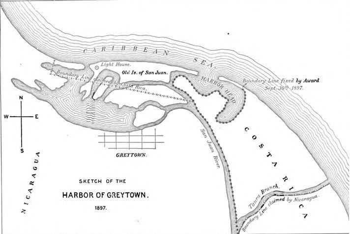
Español: Mapa de la desembocadura del San Juan elaborado por E.P.Alexander en 1897 de acuerdo a lo estipulado en el Laudo Cleveland (1888), previo a la elaboración del primer laudo Alexander (1898) para definir la frontera entre Costa Rica y Nicaragua. |
| Date | |
| Source | Actas y laudos Alexander. Folio 33. Archivo Nacional de Costa Rica www.archivonacional.go.cr. Escaneado. |
| Author | E.P.Alexander (1897) |
Licensing
edit
|
This work is in the public domain in its country of origin and other countries and areas where the copyright term is the author's life plus 100 years or fewer. | |
| This file has been identified as being free of known restrictions under copyright law, including all related and neighboring rights. | |
File history
Click on a date/time to view the file as it appeared at that time.
| Date/Time | Thumbnail | Dimensions | User | Comment | |
|---|---|---|---|---|---|
| current | 05:47, 20 October 2011 | | 712 × 475 (50 KB) | Rodtico21 (talk | contribs) | {{Information |Description ={{es|1=Croquis elaborado por E.P.Alexander durante la elaboración del primer laudo para definir los límites entre Costa Rica y Nicaragua. 1898.}} |Source =Actas y laudos Alexander. Folio 33. Archivo Nacional de Cos |
You cannot overwrite this file.
File usage on Commons
There are no pages that use this file.