File:Cross-laminations in proglacial lacustrine facies (Konnarock Formation, Neoproterozoic, ~750 Ma; Grassy Branch Outcrop - Rt. 603 roadcut, Smyth County, Virginia, USA) 2 (30485395802).jpg

Original file (2,802 × 2,583 pixels, file size: 4.97 MB, MIME type: image/jpeg)
Captions
Captions
Summary edit
_2_(30485395802).jpg&action=edit§ion=1)
| Description |
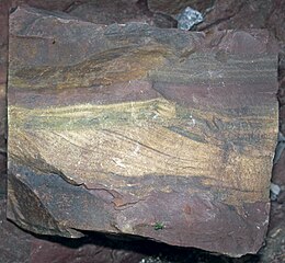
Cross-laminations in proglacial lacustrine sedimentary rock from the Precambrian of Virginia, USA. The Snowball Earth Glaciations during the Neoproterozoic were the most significant ice ages that Earth ever experienced - two or three of them occurred in succession. The most extreme models describing Snowball Earth have glacial ice completely covering all continents and all oceans, even at the equator. Some models, called “Slushball Earth”, have Earth’s equatorial oceanic areas not completely frozen over. Each Snowball Earth Glaciation was followed by a super-greenhouse climate. The resulting sedimentary record of these “freeze-fry” events typically consists of glacial tillites and overlying cap carbonates. These units are preserved at many localities on Earth. The rock shown above is interbedded sandstone and rhythmically laminated argillite (= a very low-grade metamorphic rock formed by slight alteration of shale). The light-colored material is sandstone. The dark maroon-colored material is argillite. Published research has identified the sediments in the argillite as proglacial lacustrine turbidites - they appear to be varves (rhythmites). Varves are common sedimentary units in Pleistocene proglacial lake settings. This is a Snowball Earth equivalent. The rhythmicity reflects seasonal changes (summer-winter-summer-winter, etc.). Demonstrable annual layering is scarce in the sedimentary rock record. The sandstone portion of the rock has cross-laminations, formed by a one-directional current. Stratigraphy: Konnarock Formation, Neoproterozoic, ~750 Ma Locality: Grassy Branch Outcrop - roadcut on the northern side of Rt. 603, just downstream from the Big Laurel Creek-Grassy Branch confluence, west of the town of Troutdale & east of the town of Konnarock, southern Smyth County, southwestern Virginia, USA (36º 40.900’ North latitude, 81º 33.988’ West longitude) |
| Date | |
| Source | Cross-laminations in proglacial lacustrine facies (Konnarock Formation, Neoproterozoic, ~750 Ma; Grassy Branch Outcrop - Rt. 603 roadcut, Smyth County, Virginia, USA) 2 |
| Author | James St. John |
Licensing edit
_2_(30485395802).jpg&action=edit§ion=2)
- You are free:
- to share – to copy, distribute and transmit the work
- to remix – to adapt the work
- Under the following conditions:
- attribution – You must give appropriate credit, provide a link to the license, and indicate if changes were made. You may do so in any reasonable manner, but not in any way that suggests the licensor endorses you or your use.
| This image was originally posted to Flickr by James St. John at https://flickr.com/photos/47445767@N05/30485395802. It was reviewed on 24 June 2017 by FlickreviewR and was confirmed to be licensed under the terms of the cc-by-2.0. |
File history
Click on a date/time to view the file as it appeared at that time.
| Date/Time | Thumbnail | Dimensions | User | Comment | |
|---|---|---|---|---|---|
| current | 17:46, 24 June 2017 | | 2,802 × 2,583 (4.97 MB) | Ser Amantio di Nicolao (talk | contribs) | Transferred from Flickr via Flickr2Commons |
You cannot overwrite this file.
File usage on Commons
There are no pages that use this file.
_2_(30485395802).jpg&oldid=871344352)