File:Crowleys Ridge Parkway color relief - Arkansas only.png
Size of this preview: 176 × 599 pixels. Other resolutions: 70 × 240 pixels | 489 × 1,663 pixels.
Original file (489 × 1,663 pixels, file size: 863 KB, MIME type: image/png)
Captions
Captions
Add a one-line explanation of what this file represents
Summary edit
| Description |
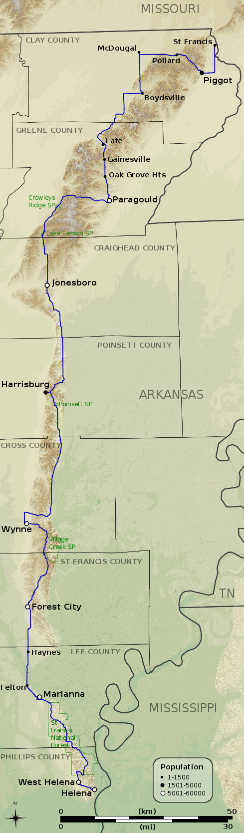
English: Color relief map of the Arkansas portion of the Crowley's Ridge Parkway. Route information from an Arkansas Delta Byways brochure[1]; GIS data from Arkansas Geographic Information Office[2] and the National Atlas of the United States. |
| Date | |
| Source | Own work |
| Author | Kbh3rd |
| Geographic coordinates | ||
|---|---|---|
| Location | Latitude | Longitude |
| Center | 35°29'48.15" | 90°28'33.01"W |
| Lower Left | 34°25'22.60" | 90°53'32.77"W |
| Lower Right | 34°24'26.32" | 90° 7'31.01"W |
| Upper Left | 36°35'6.99" | 90°50'6.52"W |
| Upper Right | 36°34'6.06" | 90° 2'49.91"W |
| NAD83 / UTM zone 15N | ||
|---|---|---|
| Location | Easting | Northing |
| Center | 728957.803 | 3931057.862 |
| Lower Left | 693674.903 | 3811067.138 |
| Lower Right | 764240.704 | 3811067.138 |
| Upper Left | 693674.903 | 4051048.586 |
| Upper Right | 764240.704 | 4051048.586 |
World file edit
For NAD83 / UTM zone 15N:
144.306343
0
0
-144.306343
693674.903000
4051048.586000
Licensing edit
I, the copyright holder of this work, hereby publish it under the following licenses:
This file is licensed under the Creative Commons Attribution-Share Alike 3.0 Unported license.
- You are free:
- to share – to copy, distribute and transmit the work
- to remix – to adapt the work
- Under the following conditions:
- attribution – You must give appropriate credit, provide a link to the license, and indicate if changes were made. You may do so in any reasonable manner, but not in any way that suggests the licensor endorses you or your use.
- share alike – If you remix, transform, or build upon the material, you must distribute your contributions under the same or compatible license as the original.

|
Permission is granted to copy, distribute and/or modify this document under the terms of the GNU Free Documentation License, Version 1.2 or any later version published by the Free Software Foundation; with no Invariant Sections, no Front-Cover Texts, and no Back-Cover Texts. A copy of the license is included in the section entitled GNU Free Documentation License. |
You may select the license of your choice.
File history
Click on a date/time to view the file as it appeared at that time.
| Date/Time | Thumbnail | Dimensions | User | Comment | |
|---|---|---|---|---|---|
| current | 05:31, 23 May 2011 | 489 × 1,663 (863 KB) | Kbh3rd (talk | contribs) | {{Information |Description ={{en|1=Color relief map of the Arkansas portion of the Crowley's Ridge Parkway. Route information from an Arkansas Delta Byways brochure[http://www.deltabyways.com/getting-ar |
You cannot overwrite this file.
File usage on Commons
There are no pages that use this file.
File usage on other wikis
The following other wikis use this file:
- Usage on en.wikipedia.org