File:Curiosity Traverse Map Through Sol 29.jpg

Original file (3,300 × 2,550 pixels, file size: 1.49 MB, MIME type: image/jpeg)
Captions
Captions
Summary
edit
| Description |
English: 09.06.2012
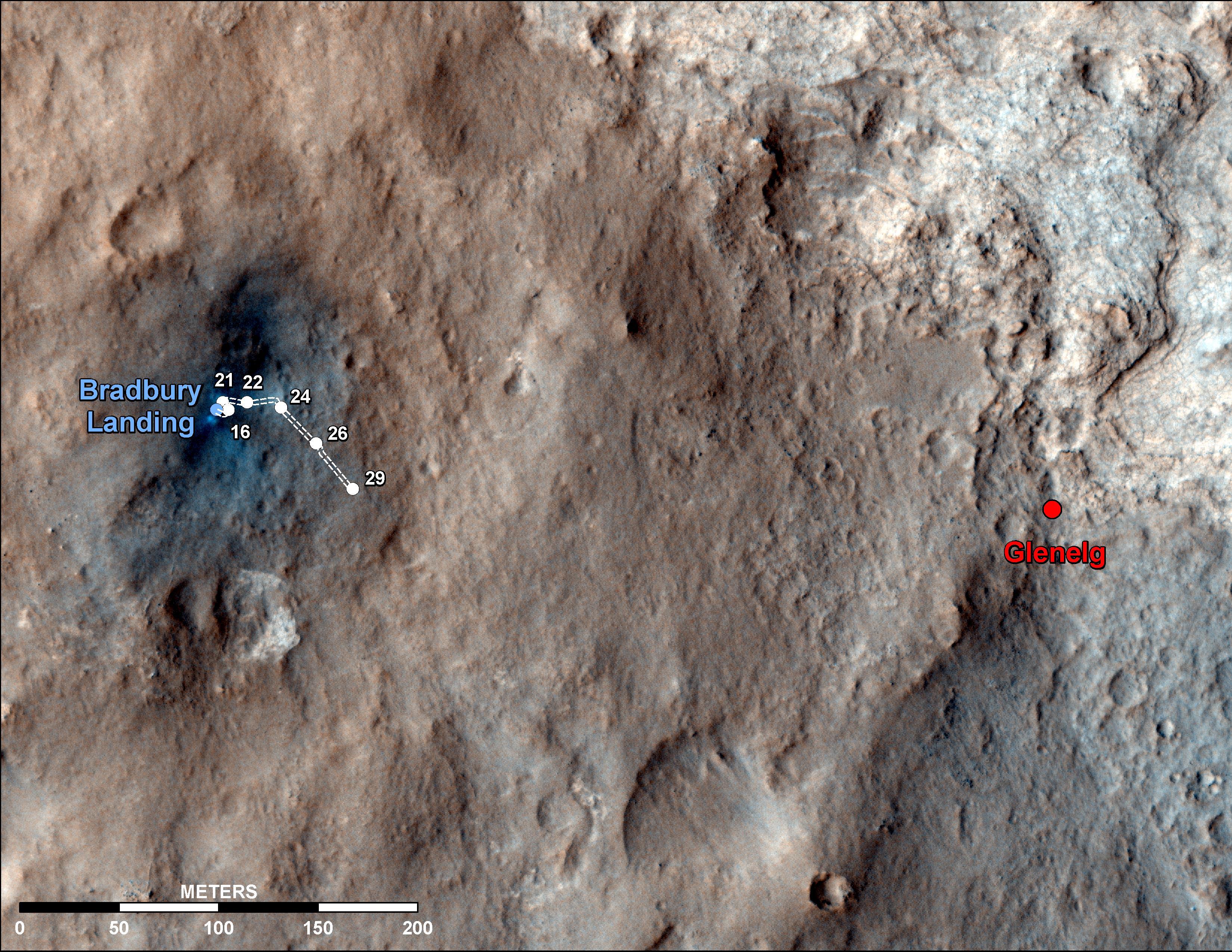
Curiosity Traverse Map Through Sol 29 This map shows the route driven by NASA's Mars rover Curiosity through the 29th Martian day, or sol, of the rover's mission on Mars (Sept. 4, 2012). The route starts where the Mars Science Laboratory spacecraft placed the rover, a site subsequently named Bradbury Landing. The line extending toward the right (eastward) from Bradbury Landing is the rover's path. Numbering of the dots along the line indicate the sol numbers of each drive. North is up. The scale bar is 200 meters (656 feet). By Sol 29, Curiosity had driven at total of 358 feet (109 meters). At the location reached by the Sol 29 drive, the rover began several sols of arm characterization activities. The Glenelg area farther east is the mission's first major science destination, selected as likely to offer a good target for Curiosity's first analysis of powder collected by drilling into a rock. The image used for the map is from an observation of the landing site by the High Resolution Imaging Science Experiment (HiRISE) instrument on NASA's Mars Reconnaissance Orbiter.Polski: Mapa trasy przebytej przez łazik Curiosity do Sol 29 Mapa ta, pokazuje trasę przebytą przez należący do NASA łazik Curiosity do 29 marsjańskiego dnia, (Sol 29), misji łazika na Marsie (do 04 września 2012). Trasa rozpoczęła się tam, gdzie sonda Mars Science Laboratory umieściła łazik, w miejscu później nazwanym "Bradbury Landing". Linia wychodząca w prawo (w kierunku wschodnim) z "Bradbury Landng" wskazuje trasę łazika. Numeracja punktów wzdłuż linii wskazuje kolejne marsjańskie dni, odnoszące się do danych odcinków trasy. Północ jest u góry. Długość paska skali w terenie, odpowiada odcinkowi o długości dwustu metrów. W ciągu 29 marsjańskiego dnia łazik przebył w sumie 109 metrów. Na pozycji osiągniętej 29 marsjańskiego dnia, łazik rozpoczął działalność związaną z ćwiczeniami ramienia robotycznego. Obszar Glenelg położony dalej na wschód, jest pierwszym z głównych terenów, wybranym jako mogący zaoferować dobry cel, dla pierwszej analizy zebranych próbek skał, uzyskanych poprzez użycie wiertarki udarowej. Obraz użyty do wykonania mapy pochodzi zdjęcia wykonanego podczas obserwacji lądowiska przez teleskop zwierciadlany HiRISE zamontowany na należącym do NASA orbiterze Mars Reconnaissance Orbiter. Image Credit: NASA/JPL-Caltech/Univ. of Arizona |
| Date | |
| Source | http://photojournal.jpl.nasa.gov/jpeg/PIA16148.jpg |
| Author | NASA/JPL-Caltech/Univ. of Arizona |
Licensing
edit
| This file is in the public domain in the United States because it was solely created by NASA. NASA copyright policy states that "NASA material is not protected by copyright unless noted". (See Template:PD-USGov, NASA copyright policy page or JPL Image Use Policy.) | ||
 |
Warnings:
|
File history
Click on a date/time to view the file as it appeared at that time.
| Date/Time | Thumbnail | Dimensions | User | Comment | |
|---|---|---|---|---|---|
| current | 07:49, 11 September 2012 | | 3,300 × 2,550 (1.49 MB) | Originalwana (talk | contribs) | {{Information |Description ={{en|1=This map shows the route driven by NASA's Mars rover Curiosity through the 29th Martian day, or sol, of the rover's mission on Mars (Sept. 4, 2012). The route starts where the Mars Science Laboratory spacecraft pl... |
You cannot overwrite this file.
File usage on Commons
There are no pages that use this file.
File usage on other wikis
The following other wikis use this file:
- Usage on pl.wikipedia.org